Filter: Categories of Wisconsin Historical Images
Filter: FORMAT_TYPE of drawings
Filter: Subject of lakes
Filter: Categories of Wisconsin Historical Images
Filter: FORMAT_TYPE of drawings
Filter: Subject of lakes

| Date: | 1936 |
|---|---|
| Description: | This map is red and black ink on tracing cloth and is oriented with north to the upper left. This hand-drawn map shows a central portion of the military ro... |

| Date: | 1851 |
|---|---|
| Description: | Plat map of the Town of Madison (Township 7N, Range 9E), from Volume 4, Federal Survey Plat Books. |

| Date: | 1832 |
|---|---|
| Description: | Hand-drawn map in two parts of the route of Governor J.D. Doty. Probably made by Doty in 1832 as a result of his travels with Alexander J. Center. |

| Date: | 1852 |
|---|---|
| Description: | Pencil drawing of Madison landscape as seen from University Hill. The main street in the center is State Street, and the building with Greek columns in the... |

| Date: | 1852 |
|---|---|
| Description: | Pencil drawing of view overlooking Madison. The sketch looks down North Hamilton Street from the capitol. Rutted, irregular streets and frame houses mark ... |

| Date: | 1833 |
|---|---|
| Description: | Map of part of the military road from Fort Crawford to Fort Howard. "Recorded on pages 668.669 Book B." Surveyed by Lieut. Center. Scale: 2 miles = 1 inch. |
| Date: | 1938 |
|---|---|
| Description: | Reproduction of a color rendering of Olin Terraces, an early proposal for a Madison civic center by Frank Lloyd Wright. This perspective is the view from ... |
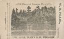
| Date: | |
|---|---|
| Description: | View of the Cliff House on the lake, with pine trees surrounding the property, and a cliff behind the building. |
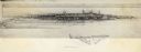
| Date: | 08 1852 |
|---|---|
| Description: | Pencil drawing of a lake shoreline. A few trees frame the arc of the shore and steamboats are visible along the distant shore. |

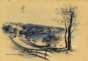
| Date: | 08 1852 |
|---|---|
| Description: | Pencil drawing of Milwaukee Harbor with large sailboats on the water. In the minimalist depiction the sandy shoreline with short plant growth sweeps aroun... |

| Date: | 1853 |
|---|---|
| Description: | Farwell's Mill on the Yahara River at Lake Mendota. |

| Date: | 07 01 1836 |
|---|---|
| Description: | Original plat map of the town of Madison on the four lakes. |

| Date: | 06 28 1958 |
|---|---|
| Description: | Official plat map drawn in ink and watercolor, T. 15 N, R. 11 E. |

| Date: | |
|---|---|
| Description: | Hand-drawn, folded extension of map, rendered on notebook paper. |
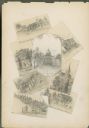
| Date: | 1885 |
|---|---|
| Description: | Wisconsin State Capitol surrounded by seven miniature drawings of Madison images. |
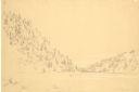
| Date: | 1852 |
|---|---|
| Description: | Devil's Lake from shore flanked by steep tree-covered hillsides. A small solitary rowboat floats near the distant shore. |
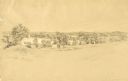
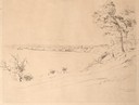
| Date: | 1852 |
|---|---|
| Description: | Pencil drawing of trees around the shore of a lake from across a field. |

| Date: | 1941 |
|---|---|
| Description: | Hand-drawn, watercolor and ink, map of Lake Mendota. Locations and many small figures appear around the shore with explanations referring to Indian legends... |

| Date: | 1906 |
|---|---|
| Description: | Hand-drawn topographical map of the Turville Estate. |
If you didn't find the material you searched for, our Library Reference Staff can help.
Call our reference desk at 608-264-6535 or email us at: