 Filter: Categories of Wisconsin Historical Images
Filter: FORMAT_TYPE of drawings
Filter: Subject of fortification
Filter: Categories of Wisconsin Historical Images
Filter: FORMAT_TYPE of drawings
Filter: Subject of fortification

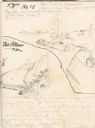
| Date: | 1936 |
|---|---|
| Description: | This map is red and black ink on tracing cloth and is oriented with north to the upper left. This hand-drawn map shows a central portion of the military ro... |
| Date: | 1849 |
|---|---|
| Description: | Fort Childs or New Fort Kearny in Nebraska Sketched by Wilkins on his 151-day journey from Missouri to California on the Overland Trail (also known as the ... |
| Date: | 05 1849 |
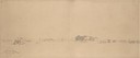
|---|---|
| Description: | Old Fort Kearney (Nebraska City). Sketched by Wilkins on his 151-day journey from Missouri to California on the Overland Trail (also known as the Oregon Tr... |

| Date: | 06 24 1849 |
|---|---|
| Description: | Original wash drawing of Fort Laramie, Wyoming (actually Fort John; see note below). Sketched by Wilkins on his 151-day journey from Missouri to California... |
| Date: | 05 1849 |
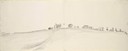
|---|---|
| Description: | Fort Leavenworth with trees, buildings and American flag. The fort was established by Colonel Henry Leavenworth to protect the Santa Fe trail against the I... |

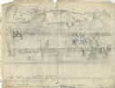
| Date: | 1833 |
|---|---|
| Description: | Map of part of the military road from Fort Crawford to Fort Howard. "Recorded on pages 668.669 Book B." Surveyed by Lieut. Center. Scale: 2 miles = 1 inch. |
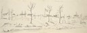
| Date: | 07 25 1849 |
|---|---|
| Description: | Fort Bridger in Wyoming, with wagon parts and teepees, where Wilkins camped for a night; sketched by Wilkins on his 151-day journey from Missouri to Califo... |
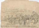
| Date: | |
|---|---|
| Description: | View of a fort with fortified walls and a flag flying from the fort. A river runs on the right of the image. A boat with sails floats on the river. Sold... |

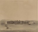
| Date: | 1851 |
|---|---|
| Description: | Several men rowing in a boat near Fort Howard that has an American Flag, barracks, and various related military buildings enclosed behind a wall. |
| Date: | |
|---|---|
| Description: | Drawing of a section of a completed part of Fort Cairo facing the confluen [sic] of the Mississippi and Ohio rivers. |
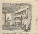
| Date: | |
|---|---|
| Description: | Drawing of a soldier holding a cup, standing next to his bunk at Fort Holt. Civil War firearms are in the closet on the right. Another man is in the backgr... |
| Date: | 10 03 1862 |
|---|---|
| Description: | "General Rosecranz and staff huredly [sic] erecting earthworks during the Battle at Corinth. The enemy driving in our lines." Men are on horses on a... |
| Date: | 10 03 1862 |
|---|---|
| Description: | "Combined Confederate attack upon [Batteries] Robinette and Davis the attack on Battery Robinette being defeated and that on Davis resulting in the defeat ... |
| Date: | 04 1862 |
|---|---|
| Description: | Notes include: Sketch of Battle of Island #10. Sketch of Fort Pillow Tennessee. Gen. Pope had command of the land troops. |
| Date: | 02 15 1862 |
|---|---|
| Description: | "The 2nd and 7th Iowa and the 52nd Indiana headed by General Smith storming up the rebel works at Fort Donelson causing its surrender to General Grant the ... |

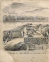
| Date: | |
|---|---|
| Description: | A magazine (storage, usually for ammunition) at Farmington near Grand Junction (Tennessee). Soldiers are working around a storage area dug into the raised ... |

| Date: | |
|---|---|
| Description: | Exterior of Fort Donelson with landscape including sparse buildings and trees. |

| Date: | |
|---|---|
| Description: | "Hospital and (indecipherable) during the last days battle at Fort Donelson on the Tennessee." Building with people and several trees. |

| Date: | |
|---|---|
| Description: | A hand-drawn map of the state of Missouri with a separate drawing of a map showing Forts Henry and Donelson. The Missouri map includes Jefferson City and s... |

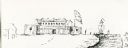
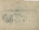
| Date: | 1830 |
|---|---|
| Description: | Fort Winnebago from an original drawing by Jefferson Davis. |
If you didn't find the material you searched for, our Library Reference Staff can help.
Call our reference desk at 608-264-6535 or email us at: