Filter: Categories of Wisconsin Historical Images
Filter: FORMAT_TYPE of drawings
Filter: Subject of arts
Filter: Year of 1800-1899
Filter: Categories of Wisconsin Historical Images
Filter: FORMAT_TYPE of drawings
Filter: Subject of arts
Filter: Year of 1800-1899
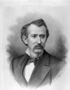
| Date: | 1880 |
|---|---|
| Description: | Charcoal portrait of George Baxter Burrows. A Wisconsin State Senator (1878-1882) and real estate broker, he willed his twelve-acre Lake Mendota frontage e... |

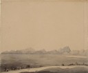
| Date: | 1852 |
|---|---|
| Description: | Pencil drawing of view overlooking Madison. The sketch looks down North Hamilton Street from the capitol. Rutted, irregular streets and frame houses mark ... |

| Date: | 1850 |
|---|---|
| Description: | Lithograph of a map drawn to indicate a mine on land owned by Mineral Point Mining Co. in the lead region of southwestern Wisconsin. |
| Date: | 1838 |
|---|---|
| Description: | Pencil sketch of a building owned by the Rodolf family along a commercial street. |
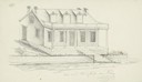
| Date: | 1838 |
|---|---|
| Description: | Pencil sketch of a stone house with a porch the full length of the dwelling, supported by 6 columns. |
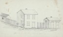
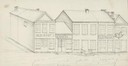
| Date: | 1838 |
|---|---|
| Description: | Pencil sketch of buildings, including the Post Office. |
| Date: | 07 03 1849 |
|---|---|
| Description: | The Black Hills sketched by Wilkins on his 151-day journey from Missouri to California on the Overland Trail (also known as the Oregon Trail). |
| Date: | 07 03 1849 |
|---|---|
| Description: | Wilkins' wagons ferrying across the North Platte River in eastern Wyoming; sketched by Wilkins on his 151-day journey from Missouri to California on the Ov... |
| Date: | 07 07 1849 |
|---|---|
| Description: | The Buttes, Wyoming and Sweetwater River; sketched by Wilkins on his 151-day journey from Missouri to California on the Overland Trail (also known as the O... |
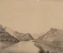
| Date: | 07 10 1849 |
|---|---|
| Description: | The clay hills that were formed by the Sweetwater River in Wyoming; sketched by Wilkins on his 151-day journey from Missouri to California on the Overland ... |
| Date: | 07 10 1849 |
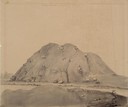
|---|---|
| Description: | Independence Rock (the perceived midway point on the Oregon Trail),Wyoming, with two wagons unhitched at the base of the rock; sketched by Wilkins on his 1... |
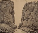
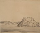
| Date: | 07 10 1849 |
|---|---|
| Description: | Devil's Gate in Wyoming; sketched by Wilkins on his 151-day journey from Missouri to California on the Overland Trail (also known as the Oregon Trail). |
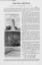
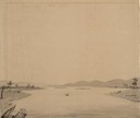
| Date: | 07 11 1849 |
|---|---|
| Description: | Sweetwater River in Wyoming; sketched by Wilkins on his 151-day journey from Missouri to California on the Overland Trail (also known as the Oregon Trail). |

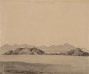
| Date: | 06 20 1849 |
|---|---|
| Description: | Jail and Courthouse Rocks in Nebraska; Sketched by Wilkins on his 151-day journey from Missouri to California on the Overland Trail (also known as the Oreg... |
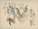
| Date: | 09 1890 |
|---|---|
| Description: | A drawing of a war dance including Kiowas, Osages, and Pawnees drawn by a Comanche boy, at Kiowa, Comanche, and Wichita Agency, Oklahoma. |

| Date: | 1859 |
|---|---|
| Description: | Color drawing of beavers working on and living at their dams. |

| Date: | 1833 |
|---|---|
| Description: | Drawing on a faint grid with Lake Michigan on the right, and the rivers on the left. Labeled is an Indian Village, J. Veiu, S. Juneau, and P. Juneau. Alo... |
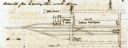
| Date: | 10 19 1847 |
|---|---|
| Description: | Sketch of the Camden Depot in a letter from John McRae to James Gadsdeg. |
If you didn't find the material you searched for, our Library Reference Staff can help.
Call our reference desk at 608-264-6535 or email us at: