 Filter: Categories of Wisconsin Historical Images
Filter: FORMAT_TYPE of drawings
Filter: Creator Name of Unknown
Filter: Categories of Wisconsin Historical Images
Filter: FORMAT_TYPE of drawings
Filter: Creator Name of Unknown

| Date: | 1850 |
|---|---|
| Description: | This map of the Town of Lake is ink and pencil on paper and shows lots and acreages, reserved land, and public squares. The bottom of the map includes a ke... |

| Date: | 1800 |
|---|---|
| Description: | This map of the Little Kaukalin Region is ink on paper and shows Little Kaukalin Rapids, Black Bird Island, buildings, trails, meadows and woods, and a sug... |

| Date: | 1900 |
|---|---|
| Description: | The map is watercolor, pencil, and ink on tracing cloth and shows plats of both cities, local streets, railroads, mills, township divisions, bridges, and p... |

| Date: | 1900 |
|---|---|
| Description: | This map is pencil on tracing paper and shows profiles of local streets. Sheet 6 is hand-colored and some sheets are missing. |
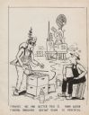
| Date: | 05 1964 |
|---|---|
| Description: | Black and white cartoon depicting two men in an apiary. One man is standing over a beehive with ridiculous electrical equipment strapped to his chest and h... |
| Date: | 1930 |
|---|---|
| Description: | This map is pen and pencil on paper and shows local streets, lots by number, and section divisions. |
| Date: | 1967 |
|---|---|
| Description: | This map is pen and pencil on paper and shows land ownership by name, blocks, lots, local streets, and railroads. To the right of the title the map reads: ... |

| Date: | 1882 |
|---|---|
| Description: | This map is ink on cardboard and shows the location of military forts over the course of years. Also shown are points of interest, streets, the Mississippi... |

| Date: | 1800 |
|---|---|
| Description: | This map is pencil on tracing paper and shows marshes, the Wisconsin River, Indian trails, and Indian boundary line. The upper left corner reads: "Let sect... |

| Date: | 1800 |
|---|---|
| Description: | This map is ink and watercolor on paper and shows the main channel and sand bars in the Mississippi River between villages. |

| Date: | 1882 |
|---|---|
| Description: | This map is ink and watercolor on paper and shows numbered plots, the public square, streets, Lake St. Croix and the Mississippi River. |

| Date: | 1876 |
|---|---|
| Description: | This map is ink on tracing cloth and shows the Black River, French Slough, Little French Slough, the southern portion of North La Crosse, the Milwaukee & S... |

| Date: | |
|---|---|
| Description: | A pencil sketch of a shell gorget made on stationary paper with the Clarence T. Olen Farms letterhead. |

| Date: | 04 15 1911 |
|---|---|
| Description: | A sketch of artifacts, including pottery and a copper implement. There are notes written next to the drawings. |

| Date: | 04 15 1915 |
|---|---|
| Description: | A sketch of Little Lake Butte des Morts and the surrounding area, including Neenah and Menasha. |

| Date: | 1828 |
|---|---|
| Description: | This plat map is pen-and-ink and shows landowners, the Mississippi River, the Marais de St. Friole, Fort Crawford, the town commons, and the Village of St.... |

| Date: | 09 01 1856 |
|---|---|
| Description: | This map is pen-and-ink and shows farm lots, other lots of land sectioned by acres, bluffs, and a coulee. Also included are notations in pencil and blue in... |

| Date: | 1856 |
|---|---|
| Description: | This map is ink and color on paper and mounted on cloth. The map shows lot and block numbers, streets, a railroad, and the Kickapoo River. Some lots are c... |

| Date: | |
|---|---|
| Description: | This map is pen-and-ink on tracing paper with a mounted legend and shows the Kickapoo River, Indian mounds, the 1st Fort Crawford, an Indian Agency, the si... |

| Date: | 1969 |
|---|---|
| Description: | This map is pen and ink on paper and shows the location of churches, local streets, railroads, parks, Middleton, Shorewood Hills, Monona, Maple Bluff, McFa... |
If you didn't find the material you searched for, our Library Reference Staff can help.
Call our reference desk at 608-264-6535 or email us at: