 Filter: Categories of Wisconsin Historical Images
Filter: FORMAT_TYPE of drawings
Filter: Creator Name of Unknown
Filter: Categories of Wisconsin Historical Images
Filter: FORMAT_TYPE of drawings
Filter: Creator Name of Unknown

| Date: | 1879 |
|---|---|
| Description: | This hand-colored profile shows the depth and the fall of an approximately 14 mile long stretch of the Beaver Dam and Crawfish rivers in the towns of Lowel... |

| Date: | 1835 |
|---|---|
| Description: | This map is pen-and-ink on paper. The map shows landowners in "Milwalky" or present day Milwaukee. Includes "list of property offered to Mr. Walker". The m... |
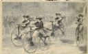
| Date: | 12 1868 |
|---|---|
| Description: | Engraved view of four women racing on bicycles. Spectators in the background are behind a fence. |

| Date: | 06 1837 |
|---|---|
| Description: | Pen-and-ink on paper. Shows riverside property west of the Milwaukee River. Inscribed by several early Milwaukee settlers, including Henry W. Cleveland, Cy... |

| Date: | 1840 |
|---|---|
| Description: | Pen-and-ink on paper. Map shows 1840’s homes with owner names, a Native American cemetery, and other points of interest. Relief shown by hachures. Oriented... |

| Date: | 1800 |
|---|---|
| Description: | Ink on tracing cloth. Shows property owners in block 69, between Fourth and Third Street. |

| Date: | 1848 |
|---|---|
| Description: | Pen-and-ink on paper. Includes certifications signed by "Geo R. Bluntz, District Survey of Grant Co. W.T." and Ben C. Eastman. |

| Date: | 1900 |
|---|---|
| Description: | Pen and pencil on tracing paper. Shows landownership by name, local streets, local businesses, mill pond, creek, and proposed railroad. |

| Date: | 1800 |
|---|---|
| Description: | Ink and watercolor on tracing paper. Shows plat of town, local streets, Fond du Lac River, and part of Lake Winnebago. |

| Date: | 1800 |
|---|---|
| Description: | An ink on paper map for a plan of mounds in Milwaukee county. The map is situated pointing north. |

| Date: | 1830 |
|---|---|
| Description: | Plat map showing lots and streets. A few lots are marked with names, including: Boyd, Newton, Williams, Baird, Suydam, etc. |

| Date: | 1850 |
|---|---|
| Description: | Map is pen and pencil on paper. The map shows roads, creeks, and the Chequamegon Bay. The map is undated and prepared sometime between the establishment of... |

| Date: | 1960 |
|---|---|
| Description: | A hand-drawn map showing the "Negro Percentage of Each County's Population" in Mississippi. |

| Date: | 1774 |
|---|---|
| Description: | A hand-drawn plat map of Elkcorn (Elkhorn?) Creek. |

| Date: | 1900 |
|---|---|
| Description: | This map of Bangor is ink and pencil on cloth. The map shows roads, railroads, residences, mills, the original plat of Bangor, and the Wisconsin and Wheldo... |

| Date: | 1800 |
|---|---|
| Description: | This map on two sheets shows a group of ancient mounds near the southeast corner of the city of Beloit and a group of ancient mounds north of Rockton Stati... |

| Date: | 09 20 1836 |
|---|---|
| Description: | This map is ink and watercolor on paper and is an unnamed plat. Green Bay is labeled and the plat is labeled "Section 22." One road is labeled "Road to Nav... |

| Date: | 1880 |
|---|---|
| Description: | This map of the southern part of La Crosse is pen on cloth and shows proposed streets crossing the lands of Jane Usher and the Green Bay, Winona and St. Pa... |

| Date: | 1800 |
|---|---|
| Description: | This map of North La Crosse is ink and pencil on paper and shows lot ownership and buildings. |
If you didn't find the material you searched for, our Library Reference Staff can help.
Call our reference desk at 608-264-6535 or email us at:
