 Filter: Categories of Wisconsin Historical Images
Filter: FORMAT_DIMENSIONS of unknown
Filter: Year of 1800-1899
Filter: Subject of roads
Filter: Categories of Wisconsin Historical Images
Filter: FORMAT_DIMENSIONS of unknown
Filter: Year of 1800-1899
Filter: Subject of roads
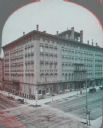
| Date: | 1880 |
|---|---|
| Description: | Stereograph of elevated view of Newhall House which was destroyed by fire in 1883. |
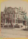
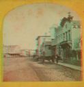
| Date: | 1874 |
|---|---|
| Description: | Stereograph of Broadway in Milwaukee. The mansion has many peaks on the roof, and the drive to the entrance is on the right. |
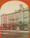
| Date: | 1886 |
|---|---|
| Description: | Stereograph. Located on Oneida Street, the opera house is three stories tall, and located across the street from a pharmacy (the Rx sign is hanging above t... |

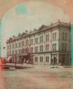
| Date: | 1866 |
|---|---|
| Description: | Stereograph. This building, which was destroyed by fire in 1866, was located in the commercial district known as Market Square. The Square was actually a t... |

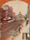
| Date: | 1875 |
|---|---|
| Description: | Stereograph of Wisconsin Street seen from Spring Street. The building on the left nearest the bridge was the Chicago, Milwaukee & St. Paul Railway's downto... |
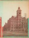
| Date: | 1870 |
|---|---|
| Description: | Stereograph; view of the earlier City Hall building, on Market Square at the corner of E. Water Street and Oneida Street. Several signs are in the image, i... |
| Date: | 1870 |
|---|---|
| Description: | Stereograph; view of store and adjoining buildings, Wisconsin and Milwaukee Streets. A large statue of a bird sits atop the store in the right of the image... |
| Date: | 1885 |
|---|---|
| Description: | Stereograph view of Chamber of Commerce at Broad and Michigan Streets. The building is the center of the image, with a telephone pole to the right, a larg... |
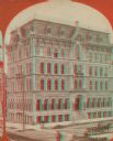
| Date: | 1890 |
|---|---|
| Description: | Stereograph; corner of Broad and Wisconsin Avenues. Built in 1870. E.T. Mix, architect. Victorian details decorate the six story building. A small pile of... |

| Date: | 1871 |
|---|---|
| Description: | Stereograph. In the right background is the building of the Trade Reporter newspaper at the corner of Main and High Streets; across the street from it is J... |

| Date: | 1874 |
|---|---|
| Description: | Stereograph of elevated view looking northwest from Exposition Building. There is a church on a street corner on the left, and the Best Brewing Company in ... |
| Date: | 1871 |
|---|---|
| Description: | A stereograph of the town square and Main Street. The three-story building visible in the center of the photograph was operated as the National Hotel. It w... |

| Date: | 1865 |
|---|---|
| Description: | This map of the Bentonville, N.C., battlefield illustrates the positions of the Union and the Confederate troops, roads, rivers, vegetation, and the names ... |

| Date: | 1865 |
|---|---|
| Description: | This map illustrates the lines of defense established by Confederate troops, under the command of General Joseph E. Johnston, at Raleigh, North Carolina, i... |

| Date: | 1876 |
|---|---|
| Description: | This map of the Battle of Iuka depicts the May 19, 1862, positions of the Union forces in blue and Confederate in red. Indicated on the map are roads, the ... |

| Date: | 1862 |
|---|---|
| Description: | This detailed map shows batteries and rifle pits, railroads, common and military roads, turnpikes, city streets and names, bridges, ferries, rural houses a... |

| Date: | 1873 |
|---|---|
| Description: | A hand-colored map of Minnesota, Wisconsin, and Michigan shows the counties, cities, villages, rivers, lakes, railroads, and steamboat routes in these stat... |

| Date: | 05 01 1899 |
|---|---|
| Description: | Map showing the Schuylkill River with roads, ferries, and points of interest from Valley Forge to Philadelphia, Pennsylvania as it appeared during the Revo... |

| Date: | 1899 |
|---|---|
| Description: | A plat map of Pleasant Springs in Dane County. |
If you didn't find the material you searched for, our Library Reference Staff can help.
Call our reference desk at 608-264-6535 or email us at:
