 Filter: Categories of Wisconsin Historical Images
Filter: FORMAT_DIMENSIONS of unknown
Filter: Subject of water
Filter: Categories of Wisconsin Historical Images
Filter: FORMAT_DIMENSIONS of unknown
Filter: Subject of water

| Date: | |
|---|---|
| Description: | Stereograph of Minnehaha Falls during summer. Text at bottom: "Among the Bluff Scenery of the Upper Mississippi. Minnehaha Falls. No. 1502." |
| Date: | |
|---|---|
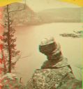
| Description: | Stereograph over Devil's Lake with Turk's Head rock formation in the foreground. |
| Date: | 1880 |
|---|---|
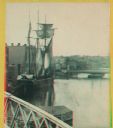
| Description: | Stereograph. Part of a bridge is visible in the lower left corner. Under the bridge is a floating pier with advertisements painted on its sides. Another br... |

| Date: | 1869 |
|---|---|
| Description: | Stereograph of the Axtell House building, with a storefront next to it advertising "Clothing Hats Caps Sailors Outfits". A bridge is on the left and a man... |
| Date: | 1880 |
|---|---|
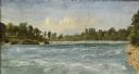
| Description: | Stereograph of the Dalles and the Saint Croix River with man in the foreground. |

| Date: | |
|---|---|
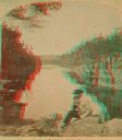
| Description: | Stereograph of the steamboat the "Dell Queen" at Chapel Gorge. A woman and a young child are sitting on the shoreline. |

| Date: | 1886 |
|---|---|
| Description: | Stereograph of several men working at dusk, knee deep in water attending to the raft. |
| Date: | 1886 |
|---|---|
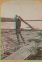
| Description: | Stereograph of photographer Henry Hamilton Bennett pulling an oar on a Wisconsin raft. |

| Date: | 1886 |
|---|---|
| Description: | Stereograph of five men standing on a log while another man chops at the log with an axe. |

| Date: | 1860 |
|---|---|
| Description: | Stereograph of the Townsend House boathouse across a lake. |
| Date: | 1900 |
|---|---|
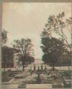
| Description: | Stereograph view toward Lake Monona from the State Capitol during the construction of the fourth capitol building. The image features the Capitol Square si... |

| Date: | 1860 |
|---|---|
| Description: | This colored map shows railroad lines east of the Mississippi as well as in the states bordering the Mississippi River. The Great Lakes and Gulf of Mexico ... |

| Date: | 1862 |
|---|---|
| Description: | The first in a series of three maps of the Virginia Peninsula. This map details the area from Williamsburg south to Fortress Monroe at Hampton Roads and sh... |

| Date: | 1862 |
|---|---|
| Description: | The second in a series of three maps of the Virginia Peninsula. This map details the area from Williamsburg north to West Point. |

| Date: | 1862 |
|---|---|
| Description: | The third in a series of three maps of the Virginia Peninsula. This map details the area from Harrison's Landing west to Richmond and shows troop positions... |

| Date: | 1865 |
|---|---|
| Description: | This map of the Bentonville, N.C., battlefield illustrates the positions of the Union and the Confederate troops, roads, rivers, vegetation, and the names ... |
| Date: | 1856 |
|---|---|
| Description: | "....The third view was twelve miles farther up the river [from De Pere], at Rapid Croche, on the border of the present Brown and Outagamie counties. It is... |

| Date: | 1873 |
|---|---|
| Description: | A hand-colored map of Minnesota, Wisconsin, and Michigan shows the counties, cities, villages, rivers, lakes, railroads, and steamboat routes in these stat... |

| Date: | 1882 |
|---|---|
| Description: | A geological map of northern Wisconsin showing the locations of different soil types in the state such as sandy soil, sandy loam, prairie loam, clayey loam... |
If you didn't find the material you searched for, our Library Reference Staff can help.
Call our reference desk at 608-264-6535 or email us at:
