Filter: Categories of Wisconsin Historical Images
Filter: FORMAT_DIMENSIONS of unknown
Filter: Subject of railroads
Filter: Categories of Wisconsin Historical Images
Filter: FORMAT_DIMENSIONS of unknown
Filter: Subject of railroads
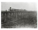
| Date: | 1890 |
|---|---|
| Description: | Wisconsin Central Railroad train on White River Bridge, with crew posing on top of cars. The bridge was 1600 feet long and 110 feet above the water. In 187... |

| Date: | |
|---|---|
| Description: | Interior of railroad bridge, with walkway below. There is a man standing on the left at the railing of the walkway. |

| Date: | 1889 |
|---|---|
| Description: | Chicago, Milwaukee & St. Paul passenger depot with several people standing in front of the building. This is the Franklin Street station on East Wilson Str... |

| Date: | 1889 |
|---|---|
| Description: | Original Chicago & North Western Railroad passenger station, 219 South Blair Street at East Wilson Street, with a few men gathered out front. Torn down in... |
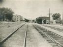
| Date: | 1955 |
|---|---|
| Description: | Chicago and North Western Railroad (CN&W) tracks between Brearly and Ingersoll Streets. |

| Date: | 1913 |
|---|---|
| Description: | A wall atlas of Sauk County, Wisconsin, displaying its 22 towns. On the left side are advertisements for local businesses. |

| Date: | 1860 |
|---|---|
| Description: | This colored map shows railroad lines east of the Mississippi as well as in the states bordering the Mississippi River. The Great Lakes and Gulf of Mexico ... |

| Date: | |
|---|---|
| Description: | This detailed map shows fortifications, headquarters, location and dates of battles, street outline of Atlanta, roads, railroads, vegetation, drainage, rel... |

| Date: | 1862 |
|---|---|
| Description: | This detailed map shows batteries and rifle pits, railroads, common and military roads, turnpikes, city streets and names, bridges, ferries, rural houses a... |

| Date: | 1873 |
|---|---|
| Description: | A hand-colored map of Minnesota, Wisconsin, and Michigan shows the counties, cities, villages, rivers, lakes, railroads, and steamboat routes in these stat... |
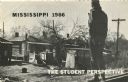
| Date: | 1966 |
|---|---|
| Description: | View from behind of a man standing on railroad tracks surveying a row of dilapidated shanties. Used on the cover of brochure with the title, 'Mississippi 1... |
If you didn't find the material you searched for, our Library Reference Staff can help.
Call our reference desk at 608-264-6535 or email us at: