 Filter: Categories of Wisconsin Historical Images
Filter: FORMAT_DIMENSIONS of unknown
Filter: Subject of land
Filter: Categories of Wisconsin Historical Images
Filter: FORMAT_DIMENSIONS of unknown
Filter: Subject of land

| Date: | |
|---|---|
| Description: | Stereograph of a winter view of a snowy landscape with ice-covered trees. |

| Date: | |
|---|---|
| Description: | Stereograph of Minnehaha Falls during summer. Text at bottom: "Among the Bluff Scenery of the Upper Mississippi. Minnehaha Falls. No. 1502." |
| Date: | |
|---|---|
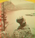
| Description: | Stereograph over Devil's Lake with Turk's Head rock formation in the foreground. |

| Date: | 1880 |
|---|---|
| Description: | Stereograph of the Dalles and the Saint Croix River with man in the foreground. |

| Date: | |
|---|---|
| Description: | Stereograph of the steamboat the "Dell Queen" at Chapel Gorge. A woman and a young child are sitting on the shoreline. |

| Date: | |
|---|---|
| Description: | Stereograph of a mock battery erected by the 79h New York Volunteer Artillery at Seabrook Point, Coosaw River. |

| Date: | 1885 |
|---|---|
| Description: | Stereograph view of Menomonie. A group of people sit on a hill in the foreground overlooking the town. |

| Date: | 1860 |
|---|---|
| Description: | This colored map shows railroad lines east of the Mississippi as well as in the states bordering the Mississippi River. The Great Lakes and Gulf of Mexico ... |

| Date: | 1861 |
|---|---|
| Description: | This map shows Manassas during the First Battle of Bull Run, in which the 2nd Wisconsin Infantry fought, and the Leesburg area, the site of the Battle of B... |
| Date: | 1906 |
|---|---|
| Description: | This oil painting is a fine weave cotton support (perhaps a bed sheet). It is signed and dated (1906) and depicts an early twentieth century rural southwes... |

| Date: | 1862 |
|---|---|
| Description: | The first in a series of three maps of the Virginia Peninsula. This map details the area from Williamsburg south to Fortress Monroe at Hampton Roads and sh... |

| Date: | 1862 |
|---|---|
| Description: | The second in a series of three maps of the Virginia Peninsula. This map details the area from Williamsburg north to West Point. |

| Date: | 1862 |
|---|---|
| Description: | The third in a series of three maps of the Virginia Peninsula. This map details the area from Harrison's Landing west to Richmond and shows troop positions... |

| Date: | 1862 |
|---|---|
| Description: | This map consists of four separate panels. The first illustrates the battlefield at Cedar Mountain on Aug. 9, 1862, where the 3rd Wisconsin Infantry fought... |

| Date: | 1865 |
|---|---|
| Description: | This map illustrates the lines of defense established by Confederate troops, under the command of General Joseph E. Johnston, at Raleigh, North Carolina, i... |

| Date: | 1876 |
|---|---|
| Description: | This map of the Battle of Iuka depicts the May 19, 1862, positions of the Union forces in blue and Confederate in red. Indicated on the map are roads, the ... |

| Date: | 1862 |
|---|---|
| Description: | This detailed map shows batteries and rifle pits, railroads, common and military roads, turnpikes, city streets and names, bridges, ferries, rural houses a... |

| Date: | 1856 |
|---|---|
| Description: | "....The third view was twelve miles farther up the river [from De Pere], at Rapid Croche, on the border of the present Brown and Outagamie counties. It is... |

| Date: | 1882 |
|---|---|
| Description: | A geological map of northern Wisconsin showing the locations of different soil types in the state such as sandy soil, sandy loam, prairie loam, clayey loam... |
If you didn't find the material you searched for, our Library Reference Staff can help.
Call our reference desk at 608-264-6535 or email us at:
