 Filter: Categories of Wisconsin Historical Images
Filter: FORMAT_DIMENSIONS of unknown
Filter: Subject of cities and towns
Filter: Subject of military art and science
Filter: Categories of Wisconsin Historical Images
Filter: FORMAT_DIMENSIONS of unknown
Filter: Subject of cities and towns
Filter: Subject of military art and science
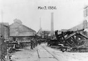
| Date: | 05 04 1886 |
|---|---|
| Description: | Edward P. Allis Reliance Works under the protection of the Wisconsin State Militia during the first general labor strike. The strike is also known as the ... |
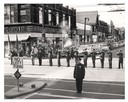
| Date: | 11 11 1957 |
|---|---|
| Description: | Uptown Post #400 Drill Team in formation firing a salute on Armistice Day while passers-by pause to pay their respects. |
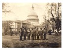
| Date: | |
|---|---|
| Description: | Survivors of the Titanic sinking with Congressman William J. Cary and his Secretary, Richard P. Momsen, in front of the United States Capitol. |

| Date: | 1870 |
|---|---|
| Description: | A stereograph of a statue of Thomas J. "Stonewall" Jackson. |

| Date: | 04 20 1861 |
|---|---|
| Description: | Elevated stereograph view of the Great Union Meeting at the New York City Union Square. |

| Date: | 1864 |
|---|---|
| Description: | Stereograph of the main building, a tenement (loft style) building, at Libby Prison. |

| Date: | |
|---|---|
| Description: | Elaborate gateway, in the shape of an arch, to the National Soldiers Home, with man and boy standing in entrance. The gateway is made of trees, covered wit... |

| Date: | 1862 |
|---|---|
| Description: | The first in a series of three maps of the Virginia Peninsula. This map details the area from Williamsburg south to Fortress Monroe at Hampton Roads and sh... |

| Date: | 1862 |
|---|---|
| Description: | The second in a series of three maps of the Virginia Peninsula. This map details the area from Williamsburg north to West Point. |

| Date: | 1862 |
|---|---|
| Description: | The third in a series of three maps of the Virginia Peninsula. This map details the area from Harrison's Landing west to Richmond and shows troop positions... |

| Date: | 1862 |
|---|---|
| Description: | This map consists of four separate panels. The first illustrates the battlefield at Cedar Mountain on Aug. 9, 1862, where the 3rd Wisconsin Infantry fought... |

| Date: | 1865 |
|---|---|
| Description: | This map illustrates the lines of defense established by Confederate troops, under the command of General Joseph E. Johnston, at Raleigh, North Carolina, i... |

| Date: | 1876 |
|---|---|
| Description: | This map of the Battle of Iuka depicts the May 19, 1862, positions of the Union forces in blue and Confederate in red. Indicated on the map are roads, the ... |

| Date: | |
|---|---|
| Description: | This detailed map shows fortifications, headquarters, location and dates of battles, street outline of Atlanta, roads, railroads, vegetation, drainage, rel... |

| Date: | 1862 |
|---|---|
| Description: | This detailed map shows batteries and rifle pits, railroads, common and military roads, turnpikes, city streets and names, bridges, ferries, rural houses a... |
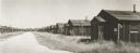
| Date: | 1947 |
|---|---|
| Description: | Abandoned enlisted men's barracks at Truax Field. |

| Date: | 05 1854 |
|---|---|
| Description: | This yellow and black wood block print broadside ties England and France's declaration of war against Russia during the Crimean War into a war against high... |

| Date: | 05 01 1899 |
|---|---|
| Description: | Map showing the Schuylkill River with roads, ferries, and points of interest from Valley Forge to Philadelphia, Pennsylvania as it appeared during the Revo... |

| Date: | 09 28 1914 |
|---|---|
| Description: | Town of Saales. Bombarded by the French on September 28. |
If you didn't find the material you searched for, our Library Reference Staff can help.
Call our reference desk at 608-264-6535 or email us at: