 Filter: Categories of Wisconsin Historical Images
Filter: FORMAT_DIMENSIONS of Unknown
Filter: Type of Map or Atlas
Filter: Subject of rivers
Filter: Categories of Wisconsin Historical Images
Filter: FORMAT_DIMENSIONS of Unknown
Filter: Type of Map or Atlas
Filter: Subject of rivers

| Date: | 1848 |
|---|---|
| Description: | In 1849, northern Wisconsin was composed of huge sectional regions such as Chippewa, Portage, Brown and Crawford, whereas southern Wisconsin was constitute... |

| Date: | 1861 |
|---|---|
| Description: | Drawn the first year of the Civil War, this colored 1861 map of Dane County shows its towns, cities and lakes. It includes insets of the wards of Madison a... |

| Date: | 1862 |
|---|---|
| Description: | Drawn the second year of the Civil War, this 1862 map of Milwaukee shows post offices, light houses, beacon lights, county buildings, elevator warehouses, ... |

| Date: | 1836 |
|---|---|
| Description: | The top map is the "Plat of Madison the Capitol of Wisconsin." The bottom map is the "Map of the Four Lake Country. Taken from the Township Maps in the U.S... |
| Date: | |
|---|---|
| Description: | Detail of Philadelphia including an illustration of the Pennsylvania Hospital and the Schuykill River. |

| Date: | 1913 |
|---|---|
| Description: | A wall atlas of Sauk County, Wisconsin, displaying its 22 towns. On the left side are advertisements for local businesses. |

| Date: | 1862 |
|---|---|
| Description: | The second in a series of three maps of the Virginia Peninsula. This map details the area from Williamsburg north to West Point. |

| Date: | 1862 |
|---|---|
| Description: | The third in a series of three maps of the Virginia Peninsula. This map details the area from Harrison's Landing west to Richmond and shows troop positions... |

| Date: | 1865 |
|---|---|
| Description: | This map of the Bentonville, N.C., battlefield illustrates the positions of the Union and the Confederate troops, roads, rivers, vegetation, and the names ... |

| Date: | 1873 |
|---|---|
| Description: | A hand-colored map of Minnesota, Wisconsin, and Michigan shows the counties, cities, villages, rivers, lakes, railroads, and steamboat routes in these stat... |

| Date: | 11 14 1942 |
|---|---|
| Description: | This pictorial map illustrates Potawatomi Indian legends from the region of Lower Phantom Lake, labeled Howitt Lake on the map, Phantom Lake, and Mukwonag... |

| Date: | 1964 |
|---|---|
| Description: | A simple map of the Mississippi Project. There are symbols at the bottom marking locations for: Voter Registration, Freedom School, Community Center and Pr... |

| Date: | 05 01 1899 |
|---|---|
| Description: | Map showing the Schuylkill River with roads, ferries, and points of interest from Valley Forge to Philadelphia, Pennsylvania as it appeared during the Revo... |

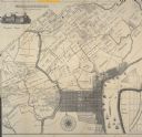
| Date: | 1894 |
|---|---|
| Description: | Sanborn map of Milwaukee, with the Milwaukee River on the left, and Water Street in the center. There are two iron draw bridges over the river. |
If you didn't find the material you searched for, our Library Reference Staff can help.
Call our reference desk at 608-264-6535 or email us at:


