Filter: Categories of Wisconsin Historical Images
Filter: FORMAT_DIMENSIONS of 9 x 7 inches
Filter: Subject of cities and towns
Filter: Community of Madison
Filter: Categories of Wisconsin Historical Images
Filter: FORMAT_DIMENSIONS of 9 x 7 inches
Filter: Subject of cities and towns
Filter: Community of Madison
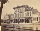
| Date: | 1873 |
|---|---|
| Description: | Ellsworth Block on North Pinckney Street between East Washington and East Mifflin Streets as seen from the Capitol Park. Storefronts include the Dry Goods ... |
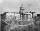
| Date: | 1890 |
|---|---|
| Description: | The expanded third Wisconsin State Capitol photographed at a time of the year when the trees in the park did not obstruct the view. As a result, the curvil... |
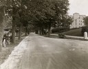
| Date: | 1922 |
|---|---|
| Description: | View of tree-lined Linden Drive includes parked motorcycles and automobiles on the University of Wisconsin campus. |
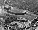
| Date: | 1954 |
|---|---|
| Description: | Aerial view of Camp Randall Stadium and Field House on the University of Wisconsin-Madison campus. |
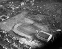
| Date: | 1934 |
|---|---|
| Description: | Aerial view of Camp Randall Stadium and Field House on the University of Wisconsin-Madison campus. |
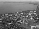
| Date: | 1947 |
|---|---|
| Description: | Aerial of University of Wisconsin-Madison campus with Camp Randall in the lower right corner and Lake Mendota, looking northeast to Maple Bluff. |
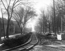
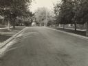
| Date: | 1906 |
|---|---|
| Description: | Newly-constructed streetcar tracks on Park Street, looking south from State Street. The eastern edge of the University of Wisconsin-Madison campus can be s... |
| Date: | 1940 |
|---|---|
| Description: | Executive Residence, 130 East Gilman Street, preceded the current one in Maple Bluff. Purchased in 1882 by Governor Jeremiah M. Rusk, the legislature bough... |
| Date: | 1951 |
|---|---|
| Description: | Executive Residence, 130 East Gilman Street, built in 1854. Used as the Executive Residence from 1883-1950. |

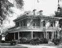
| Date: | 1900 |
|---|---|
| Description: | Exterior view of the Lucius Fairchild residence. |

| Date: | |
|---|---|
| Description: | Aerial view of the southeast, with West Broadway and the South Beltline running through the image. Also shows Nob Hill restaurant, the Toki family farm and... |
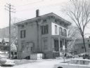
| Date: | 1922 |
|---|---|
| Description: | The J.C. Hawley house, also known as the Evergreens, which stood on a site at Badger Road that later became a highway interchange. A water tower is on the ... |
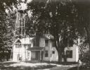
| Date: | 1958 |
|---|---|
| Description: | Home of Newell Dodge (1845-1934), who was Madison alderman from 5th ward, attorney and fuel dealer, 1127 West Johnson Street. |

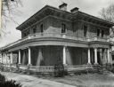
| Date: | |
|---|---|
| Description: | The Mack house, 110 East Johnson Street. Built by A.C. Isaac around 1870, it was later the residence of Professor John G.D. Mack and family, and was owned ... |

| Date: | 1940 |
|---|---|
| Description: | John C. Pew home, at 3650 Lake Mendota Drive, Shorewood Hills. This home was designed by architect Frank Lloyd Wright. Construction began in 1939, and by 1... |
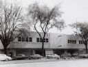
| Date: | 1954 |
|---|---|
| Description: | View of the Sears-Roebuck store on East Washington Avenue. The portion of East Washington in front of the store is full of parked automobiles. |

| Date: | |
|---|---|
| Description: | View of the east facade of the State Historical Society of Wisconsin. |

| Date: | 1932 |
|---|---|
| Description: | View of the State Office Building and numerous parked automobiles outside. |
If you didn't find the material you searched for, our Library Reference Staff can help.
Call our reference desk at 608-264-6535 or email us at: