 Filter: Categories of Wisconsin Historical Images
Filter: FORMAT_DIMENSIONS of 7 x 5 inches
Filter: Subject of transportation
Filter: Categories of Wisconsin Historical Images
Filter: FORMAT_DIMENSIONS of 7 x 5 inches
Filter: Subject of transportation
| Date: | |
|---|---|
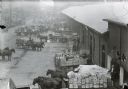
| Description: | Elevated view of the industrial warehouse district. There are horse-drawn wagons lined up along loading docks, with men working in the area. |
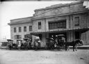
| Date: | 1913 |
|---|---|
| Description: | Horse-drawn American Express wagons in front of the Chicago & Northwestern Railway depot. |
| Date: | |
|---|---|
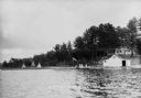
| Description: | People on the shore of East Lake (now called Lake Tahkodah) by the Gifford residence, with tipis in the distance. |

| Date: | |
|---|---|
| Description: | Dr. Anna Howard Shaw (1847-1919) turning the crank of her car. Dr. Shaw was an ordained Methodist minister, physician, temperance lecturer, woman's suffrag... |

| Date: | 11 1928 |
|---|---|
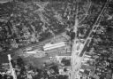
| Description: | Aerial view of Verona including businesses, houses, and the surrounding farm land. |
| Date: | 1930 |
|---|---|
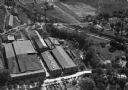
| Description: | Aerial view of the Highway Trailer plant at Edgerton. |
| Date: | 1930 |
|---|---|
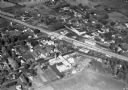
| Description: | Aerial view of the town, including business, houses, and railroad tracks cutting through the town. |

| Date: | 10 1928 |
|---|---|
| Description: | Aerial view of Sun Prairie, including the central business district, residences, and the surrounding countryside stretching to the horizon. |

| Date: | 11 1928 |
|---|---|
| Description: | Aerial view of Stoughton, including the central business district, residential areas, the Yahara River, and the surrounding countryside. |

| Date: | 11 1928 |
|---|---|
| Description: | Aerial view residential areas of Windsor and the surrounding countryside. |

| Date: | 11 1928 |
|---|---|
| Description: | Aerial view of Black Earth residential area and the surrounding countryside. |

| Date: | 11 1928 |
|---|---|
| Description: | Aerial view of Cross Plains, including residences and the surrounding countryside. |
| Date: | 1935 |
|---|---|
| Description: | Aerial view of the French Battery Company facility, East Washington Avenue, and Winnebago Street at the Union Corners intersection. |
| Date: | 10 06 1928 |
|---|---|
| Description: | Aerial view of the Janesville airport during air races including airplanes in the air, the landing field, and airport structures. |
| Date: | 1930 |
|---|---|
| Description: | Aerial view of airplane races at the Janesville airport, including airplanes on the landing field, airport structures, cars parked around the airport, and ... |

| Date: | 1930 |
|---|---|
| Description: | Aerial view of Pennco Field (Royal Airport), and Lake Monona near the city limits. A crowd is gathered at the airport to watch an air show. |
| Date: | |
|---|---|
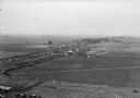
| Description: | Aerial view of Pennco Field (Royal Airport), the shoreline of Lake Monona, and the surrounding countryside near the city limits. |

| Date: | 1930 |
|---|---|
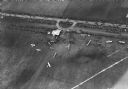
| Description: | Aerial view of the Pennco Field (Royal Airport), including the hanger and airplanes on the ground. Lake Monona, the Wisconsin State Capitol, and the Madiso... |

| Date: | |
|---|---|
| Description: | Aerial view of a crowd at the Pennco Field (Royal Airport), gathered for an aerial show. Biplanes possibly used for the show are on the airstrip. Automob... |
If you didn't find the material you searched for, our Library Reference Staff can help.
Call our reference desk at 608-264-6535 or email us at:
