 Filter: Categories of Wisconsin Historical Images
Filter: FORMAT_DIMENSIONS of 3.5 x 5.5 inches
Filter: Subject of forests and forestry
Filter: Categories of Wisconsin Historical Images
Filter: FORMAT_DIMENSIONS of 3.5 x 5.5 inches
Filter: Subject of forests and forestry
| Date: | |
|---|---|
| Description: | View looking down a rustic bridge at Copper Falls State Park. There are benches built into the bridge. |
| Date: | 1910 |
|---|---|
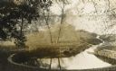
| Description: | Big spring on Lake Mendota Drive. [Merrill Springs or sometimes Merrill's Spring] |
| Date: | 1915 |
|---|---|
| Description: | The University of Wisconsin from Picnic Point. Buildings that can be seen are Bascom Hall with dome, the Students' Observatory, Washburn Observatory, the D... |

| Date: | |
|---|---|
| Description: | View of the sun shining through clouds over a lake, either Jackson Lake or Lake Namakagan. In the foreground are some trees, and more trees are visible on ... |

| Date: | |
|---|---|
| Description: | Photographic postcard view of a white-tailed deer in the forest. Autumn leaves are on the ground. Caption reads: "Babcock, Wis." |

| Date: | |
|---|---|
| Description: | Colorized photographic postcard view looking up to the dells of the Eau Claire River with trees in the background. Caption reads: "Dells of the Eau Claire ... |

| Date: | 1934 |
|---|---|
| Description: | An exterior view of a log sided building in the woods. Caption reads: "Pines and Corner of Dining Room — Fallhall Glen, Black River Falls, Wis." |

| Date: | 1950 |
|---|---|
| Description: | Wisconsin Historical Marker near Trout Lake. The marker recognizes the first ever forest patrol flight. The marker text reads: "FIRST FOREST PATROL FLI... |
| Date: | 1913 |
|---|---|
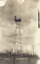
| Description: | View towards tower, with a man standing on the platform on the top. This postcard has a handwritten notation on the back: "One of the first forest protecti... |

| Date: | 03 22 1913 |
|---|---|
| Description: | A photographic postcard mailed from Boulder Junction, Wisconsin. A railroad track is running along the bank. On either side of the track are tall trees. Ca... |

| Date: | 1912 |
|---|---|
| Description: | Photographic postcard of a stand of tall trees in the forest at Trout Lake. A hat is hanging on the trunk of a tree in the center. |
| Date: | 1920 |
|---|---|
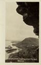
| Description: | Black and white photographic postcard view of De Soto, taken from the cliff south of town, looking north along the Mississippi River. Caption reads: "A Vie... |

| Date: | 1960 |
|---|---|
| Description: | Aerial view of the Trees for Tomorrow Environmental Center, with buildings, grounds, roads, and the Eagle River. Founded in 1944. |
| Date: | 1905 |
|---|---|
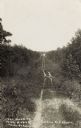
| Description: | The two-track unpaved road to "The Morey" northeast of Eagle River, on the east side of Otter Lake. Caption reads: "The Road to 'The Morey.'" |
| Date: | 1909 |
|---|---|
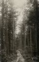
| Description: | View up a dirt path leading through a pine forest. Caption reads: "Northern Wisconsin Pine Forest, Near Hazelhurst, Wis." |

| Date: | 1932 |
|---|---|
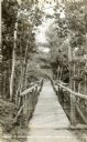
| Description: | View of a footbridge over a stream in the woods. Caption reads: "Rustic Bridge, Menomonie, Wis." |
| Date: | 1950 |
|---|---|
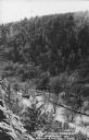
| Description: | Text on front reads: "The Old Mill Stream in the Narrows at Rock Springs, Wis." A road and the Narrows Creek run next to each other in an elevated view of ... |
| Date: | 1910 |
|---|---|
| Description: | Text on front reads: "Dells of Wisconsin and Kilbourn City." An illustrated Bird's Eye View of the Dells area with 33 numbered features: "1 - High Rock, 2 ... |
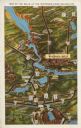
| Date: | 1931 |
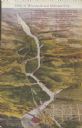
|---|---|
| Description: | Text on front reads: "Map of the Dells of the Wisconsin River Region." On reverse: "All the world knows of the Wisconsin Dells. Many noted travelers have p... |
If you didn't find the material you searched for, our Library Reference Staff can help.
Call our reference desk at 608-264-6535 or email us at: