Filter: Categories of Wisconsin Historical Images
Filter: FORMAT_DIMENSIONS of 20 x 16 inches
Filter: Subject of water
Filter: Categories of Wisconsin Historical Images
Filter: FORMAT_DIMENSIONS of 20 x 16 inches
Filter: Subject of water

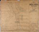
| Date: | 1867 |
|---|---|
| Description: | Bird's-eye map of Green Bay and Fort Howard, Brown Co., depicts street names and street layouts, houses, trees, and the East River. A reference key at the ... |
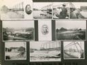
| Date: | 1914 |
|---|---|
| Description: | Multiple views of Oslo. Some pictured are the woolen mill and the dam. |
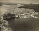
| Date: | 1924 |
|---|---|
| Description: | Aerial view of the Prairie du Sac hydroelectric plant and the surrounding landscape of the Wisconsin River. |
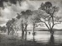
| Date: | 1964 |
|---|---|
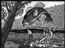
| Description: | Imaginative pen-and-ink drawing of a view from a riverbank of a fly fisherman in hip waders, who is standing in a stream while hooking a bass. The fish is ... |
If you didn't find the material you searched for, our Library Reference Staff can help.
Call our reference desk at 608-264-6535 or email us at: