Filter: Categories of Wisconsin Historical Images
Filter: County of Waukesha
Filter: Year of 1800-1899
Filter: Year of 1870-1879
Filter: Categories of Wisconsin Historical Images
Filter: County of Waukesha
Filter: Year of 1800-1899
Filter: Year of 1870-1879

| Date: | 1870 |
|---|---|
| Description: | Birds-eye drawing of Oconomowoc depicts street names and street layouts, houses, trees, Oconomowoc River, Fowler Lake, and La Belle Lake. A reference key a... |

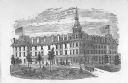
| Date: | 1874 |
|---|---|
| Description: | Bird's-eye view of Waukesha, looking southwest, with insets of State Industrial School, Court House, and Fountain Spring House. |
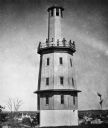
| Date: | 1877 |
|---|---|
| Description: | View of Spence's observation tower. There is a group of people standing on its upper balcony. |
| Date: | 1877 |
|---|---|
| Description: | Stereograph view of Glenn's mineral spring. |
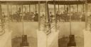
| Date: | 1877 |
|---|---|
| Description: | Stereograph view of Glenn's mineral spring with a group of people gathered around it. |
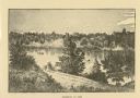
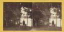
| Date: | 1876 |
|---|---|
| Description: | Distant view of Neshotah Mission. River with boaters, two people standing on riverbank, mission on hill in background. |
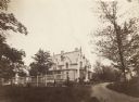
| Date: | 1870 |
|---|---|
| Description: | Townsend House and grounds with elaborate birdhouse in foreground. |

| Date: | 1870 |
|---|---|
| Description: | View from shore of sailboat anchored on the lake. There appears to be an island in the upper left. |
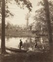
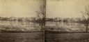
| Date: | 1870 |
|---|---|
| Description: | Two men are in the foreground on a shoreline, one standing in a boat. In the background on the other shoreline are adults and children sitting in the gras... |
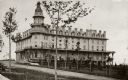
| Date: | 1870 |
|---|---|
| Description: | A large, white brick building is in the middle center, surrounded by trees. A smaller white building is in the right background. In front of the building... |

| Date: | 1873 |
|---|---|
| Description: | This late 19th century map shows the lake region around Oconomowoc in Waukesha County and eastern Jefferson County, Wisconsin. The township and range grid,... |

| Date: | 1876 |
|---|---|
| Description: | This late 19th century map by Increase Lapham shows the lake region around Oconomowoc in Waukesha County and eastern Jefferson County, Wisconsin. Cities an... |

| Date: | 1873 |
|---|---|
| Description: | Plat map of the township of Eagle (T5N, R17E) at a scale of 2 inches to one mile. |
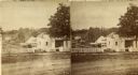
| Date: | 1870 |
|---|---|
| Description: | Stereograph view of Oconomowoc. |
| Date: | 1870 |
|---|---|
| Description: | Man wearing "stove-pipe" hat, standing looking out over a lake. |

| Date: | 1871 |
|---|---|
| Description: | This map of Waukesha shows lot owners, buildings, and various plat additions. The margins of the maps include street reference, a Waukesha business directo... |
If you didn't find the material you searched for, our Library Reference Staff can help.
Call our reference desk at 608-264-6535 or email us at: