 Filter: Categories of Wisconsin Historical Images
Filter: County of Walworth
Filter: Categories of Wisconsin Historical Images
Filter: County of Walworth

| Date: | 1938 |
|---|---|
| Description: | Label submitted to the state of Wisconsin for trademark registration. "Cream Top Beer, Whitewater Brewing Co." Pictured on the label is a man sitting at a ... |
| Date: | |
|---|---|
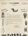
| Description: | Letterhead of N.E. Carter of Elkhorn, Wisconsin, a dealer in Indian relics and other curios from around the world, with images of individual artifacts, suc... |

| Date: | |
|---|---|
| Description: | Cabinet card of an African American man, wearing a formal suit, standing next to a young girl mounted side saddle on a pony. She is reading a book and has ... |

| Date: | 1898 |
|---|---|
| Description: | A hydrographic map of Lake Geneva that includes 15 cross sections of the depths at various points as well as a line running the length of the lake from Gen... |
| Date: | |
|---|---|
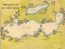
| Description: | A color, pictorial map that shows sites related to Native American villages, sites, cemeteries in the area around the lakes Geneva and Como in Walworth Cou... |
| Date: | 1936 |
|---|---|
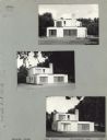
| Description: | Three views of the Fricker House on Case Street, Whitewater's first modern house, the first of its kind in Whitewater. It was finished in the winter of 193... |

| Date: | 05 01 1976 |
|---|---|
| Description: | A bride walks down the aisle in the United Church of Christ/Congregational Church in Delavan. An usher stands to the right in the background. A painting of... |
| Date: | 1840 |
|---|---|
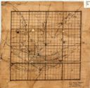
| Description: | This 19th century manuscript map shows the roads and proposed routes, villages, and lakes and streams in Walworth County, Wisconsin. |

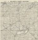
| Date: | 1896 |
|---|---|
| Description: | This late 19th century map of Walworth County, Wisconsin, shows the township and range grid, towns, sections, villages and post offices, roads, railroads, ... |

| Date: | 1900 |
|---|---|
| Description: | This 1900 map of Walworth County, Wisconsin, shows the township and range grid, towns, sections, landownership and acreages, rural residences, cities and v... |

| Date: | 01 01 1935 |
|---|---|
| Description: | This 1935 map of Walworth County, Wisconsin, shows the township and range grid, towns, sections, cities and villages, highways and roads, railroads, school... |
| Date: | 1898 |
|---|---|
| Description: | This map shows the contour depths of Lake Beulah, Booth Lake, and Army Lake (labeled East Troy Lake on the map) in Walworth County, Wisconsin, and includes... |

| Date: | 1907 |
|---|---|
| Description: | Shows post offices, railroads, country clubs, and land ownership by name. |

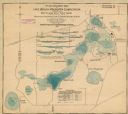
| Date: | 1898 |
|---|---|
| Description: | This map shows the contour depths of Delavan Lake and the Lauderdale Lakes in Walworth County, Wisconsin, and includes nine cross sections of the lakes. Ro... |

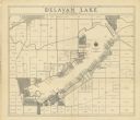
| Date: | 1930 |
|---|---|
| Description: | Shows roads, fire stations, golf course, and accommodations around Delavan Lake. "The drive around the lake is divided into zones from 0 to 900 as shown. P... |

| Date: | 1910 |
|---|---|
| Description: | Map shows routes, post offices, houses, churches, roads, and schools."June 1, 1910. E.G."Blue line print."Walworth Co., Wis. 451" -- bottom margin. |

| Date: | 1939 |
|---|---|
| Description: | This map of Walworth County, Wisconsin, shows the township and range grid, sections, cities and town, and lakes and streams in the county. It lacks the key... |

| Date: | 1939 |
|---|---|
| Description: | This map of Walworth County, Wisconsin, shows the lakes and streams flowing into the Fox River and the lakes and streams flowing into the Rock River. The d... |
| Date: | 1956 |
|---|---|
| Description: | Map shows townships and sections, landownership and acreages, roads, schools, churches, and cemeteries. |
| Date: | 1930 |
|---|---|
| Description: | Shows land ownership by name, roads, and highways. Includes manuscript annotations. |
If you didn't find the material you searched for, our Library Reference Staff can help.
Call our reference desk at 608-264-6535 or email us at: