 Filter: Categories of Wisconsin Historical Images
Filter: County of Walworth
Filter: Subject of transportation
Filter: Categories of Wisconsin Historical Images
Filter: County of Walworth
Filter: Subject of transportation

| Date: | 05 01 1976 |
|---|---|
| Description: | A bride walks down the aisle in the United Church of Christ/Congregational Church in Delavan. An usher stands to the right in the background. A painting of... |
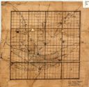
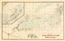
| Date: | 1840 |
|---|---|
| Description: | This 19th century manuscript map shows the roads and proposed routes, villages, and lakes and streams in Walworth County, Wisconsin. |

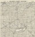
| Date: | 1896 |
|---|---|
| Description: | This late 19th century map of Walworth County, Wisconsin, shows the township and range grid, towns, sections, villages and post offices, roads, railroads, ... |

| Date: | 1900 |
|---|---|
| Description: | This 1900 map of Walworth County, Wisconsin, shows the township and range grid, towns, sections, landownership and acreages, rural residences, cities and v... |

| Date: | 01 01 1935 |
|---|---|
| Description: | This 1935 map of Walworth County, Wisconsin, shows the township and range grid, towns, sections, cities and villages, highways and roads, railroads, school... |
| Date: | 1898 |
|---|---|
| Description: | This map shows the contour depths of Lake Beulah, Booth Lake, and Army Lake (labeled East Troy Lake on the map) in Walworth County, Wisconsin, and includes... |

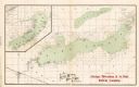
| Date: | 1907 |
|---|---|
| Description: | Shows post offices, railroads, country clubs, and land ownership by name. |

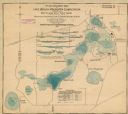
| Date: | 1898 |
|---|---|
| Description: | This map shows the contour depths of Delavan Lake and the Lauderdale Lakes in Walworth County, Wisconsin, and includes nine cross sections of the lakes. Ro... |

| Date: | 1930 |
|---|---|
| Description: | Shows roads, fire stations, golf course, and accommodations around Delavan Lake. "The drive around the lake is divided into zones from 0 to 900 as shown. P... |

| Date: | 1910 |
|---|---|
| Description: | Map shows routes, post offices, houses, churches, roads, and schools."June 1, 1910. E.G."Blue line print."Walworth Co., Wis. 451" -- bottom margin. |
| Date: | 1956 |
|---|---|
| Description: | Map shows townships and sections, landownership and acreages, roads, schools, churches, and cemeteries. |
| Date: | 1930 |
|---|---|
| Description: | Shows land ownership by name, roads, and highways. Includes manuscript annotations. |

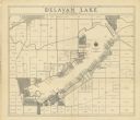
| Date: | 1966 |
|---|---|
| Description: | This 1966 map shows topography, roads, highways, golf courses, government buildings, and businesses around Delavan Lake in Walworth County, Wisconsin. Incl... |
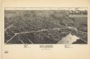
| Date: | 1884 |
|---|---|
| Description: | This map is a Birdseye view of Delavan, Wisconsin. At the bottom of the map are points of interest that correspond to numbers on the map. Many of the stree... |

| Date: | 1900 |
|---|---|
| Description: | Pen and pencil on tracing paper. Shows landownership by name, local streets, local businesses, mill pond, creek, and proposed railroad. |
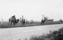
| Date: | 1920 |
|---|---|
| Description: | View across road of six camels walking and grazing along the side of a country road near Holloway Farm. They may have been circus animals going from one to... |
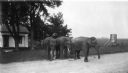
| Date: | 1920 |
|---|---|
| Description: | Three elephants on the side of the road near Holloway Farm. Two of the elephants are chained together. They may have been circus animals going from one tow... |
| Date: | 1902 |
|---|---|
| Description: | A map of Lake Geneva and Lake Delavan, also including Lake Como. |
| Date: | 1907 |
|---|---|
| Description: | A map of Lake Geneva and Lake Delavan, including Lake Como. |
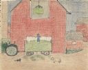
| Date: | 1945 |
|---|---|
| Description: | A man stands on top of a full hay wagon parked in front of the closed door of a red barn. Above the man a grappling hook full of hay can be seen through th... |
If you didn't find the material you searched for, our Library Reference Staff can help.
Call our reference desk at 608-264-6535 or email us at: