 Filter: Categories of Wisconsin Historical Images
Filter: County of Vilas
Filter: Subject of transportation
Filter: Categories of Wisconsin Historical Images
Filter: County of Vilas
Filter: Subject of transportation

| Date: | 1952 |
|---|---|
| Description: | This Wisconsin Conservation Dept. map shows sections, roads, rivers, and lakes in the Town of Presque Isle, Vilas County, Wisconsin as of March 1953. It do... |

| Date: | 1956 |
|---|---|
| Description: | This 1956 map shows sections, cities and villages, roads, railroads, and lakes and streams in the Eagle River area. All or part of the towns of Plum Lake, ... |

| Date: | 1974 |
|---|---|
| Description: | This 1968 map identifies resorts in the Lac du Flambeau Indian Reservation region of Wisconsin, covering parts of Iron, Vilas, Oneida, and Price counties. ... |

| Date: | 1909 |
|---|---|
| Description: | This 1909 map of northern Wisconsin and a portion of Michigan's Upper Peninsula shows the Lac du Flambeau Indian Reservation, cities and villages, railroad... |

| Date: | 1953 |
|---|---|
| Description: | This mid 20th century map of Vilas County and northeastern Oneida County, Wisconsin, shows the township and range grid, sections, cities and villages, rail... |
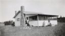
| Date: | 1927 |
|---|---|
| Description: | Four people and a dog pose in front of a small cottage with a large fieldstone fireplace. They are, from left: Armin Duchow and his father George, Potter, ... |
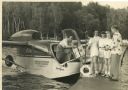
| Date: | 1950 |
|---|---|
| Description: | A man, possibly Benton C. Black, delivering films to Campo Fiesta at Trout Lake. The delivery is being made in a Seabee seaplane by the Amphibious Motion P... |

| Date: | 1931 |
|---|---|
| Description: | View from water of a child playing near a playpen on the lawn of a one and one-half story cottage on a slope along the shore of a lake. There is a stone se... |

| Date: | 1931 |
|---|---|
| Description: | View from street of a two-story "boomtown" style building which was the residence of Francis Johnson, teacher at the Mayo School, District No. 1, Town of W... |

| Date: | 1930 |
|---|---|
| Description: | Students of the Mayo School, District No. 1, have gathered with their families for a picnic at a grove on the Deerskin River. Automobiles are parked under ... |

| Date: | |
|---|---|
| Description: | Photographic postcard view downhill towards an intersection in the north woods. Three cars are driving away up the hill on the other side of the intersecti... |
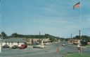
| Date: | 1968 |
|---|---|
| Description: | Elevated view of the main business district. Cars are parked in front of businesses, and are driving down the road. A flagpole and stop signs are in the fo... |
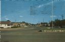
| Date: | 1966 |
|---|---|
| Description: | View of the commercial district. Cars are parked in front of businesses. A flagpole and a stop sign are on a highway island in the foreground. |

| Date: | 06 1997 |
|---|---|
| Description: | A cross on Highway 110 South of Winchester marks the spot where Tabitha Dyer was killed in a car accident. |
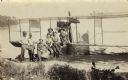
| Date: | 1912 |
|---|---|
| Description: | Picnic party on the rocks along the shore, among the Apostle Islands in Lake Superior. |

| Date: | 1911 |
|---|---|
| Description: | Yawkey-Bissell Lumber Co. main line logging railroad tracks “through virgin pine timber” south of Trout Lake. |
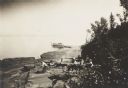
| Date: | 1915 |
|---|---|
| Description: | View from shoreline of Trout Lake of a group of six men posed with the pilot, possibly Jack Vilas, on an early seaplane or flying boat floating in the wate... |

| Date: | 1911 |
|---|---|
| Description: | View along shoreline towards the new boat house constructed of Norway pine logs at Trout Lake. It is part of the forest ranger complex. Caption reads: "Boa... |

| Date: | 03 22 1913 |
|---|---|
| Description: | A photographic postcard mailed from Boulder Junction, Wisconsin. A railroad track is running along the bank. On either side of the track are tall trees. Ca... |

| Date: | 1912 |
|---|---|
| Description: | Probably a view of a ranger camp house. There is a ladder propped outside at the front, and there is a broken window with temporary board repairs. Two men ... |
If you didn't find the material you searched for, our Library Reference Staff can help.
Call our reference desk at 608-264-6535 or email us at: