Filter: Categories of Wisconsin Historical Images
Filter: County of Trempealeau
Filter: Year of 1900-1999
Filter: Year of 1920-1929
Filter: Categories of Wisconsin Historical Images
Filter: County of Trempealeau
Filter: Year of 1900-1999
Filter: Year of 1920-1929
| Date: | 1920 |
|---|---|
| Description: | Exterior view of the two-story brick High School building with basement. A bare flagpole is on the roof. Caption reads: "High School, Arcadia, wis." |

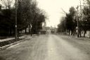
| Date: | 1920 |
|---|---|
| Description: | Elevated view of Whitehall from the Court House. A church is in the right foreground, and hills are in the distance. Caption at bottom reads: "Scene from C... |
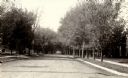
| Date: | 1920 |
|---|---|
| Description: | View down center of tree-lined road in Trempealeau. Commercial buildings are in the distance. |
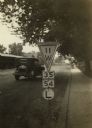
| Date: | 1925 |
|---|---|
| Description: | Wisconsin State Highway sign along STH 11 near Galesville, one of a whole new vocabulary of signage created for automobile traffic. The inverted triangle w... |
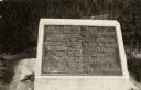
| Date: | 1926 |
|---|---|
| Description: | A marker commemorating the French fort erected by Rene Godefrey, Sieur de Linctot, which existed on this site between 1731-1736. It is thought that the sit... |
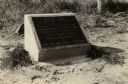
| Date: | 1926 |
|---|---|
| Description: | A marker commemorating the French fort erected by Rene Godefrey, Sieur de Linctot, which existed on this site between 1731-1736. It is thought that the sit... |

| Date: | 1925 |
|---|---|
| Description: | View from road of a two-story brick structure identified as the Melchior Hotel. See also image 67069. |

| Date: | 08 05 1925 |
|---|---|
| Description: | The Melchior Hotel on the Mississippi River, with the "brewery at near end." There is a prominent stone portion at right center with several wings or addit... |

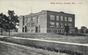
| Date: | 10 17 1923 |
|---|---|
| Description: | Exterior view of the two-story brick High School building with basement. A bare flagpole can be seen on the roof. Caption reads: "High School, Arcadia, Wis... |

| Date: | 1929 |
|---|---|
| Description: | This 1929 topographic map of Trempealeau County, Wisconsin, shows the topography, lakes, streams and wetlands, township and range grid, sections, cities an... |
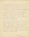
| Date: | 11 04 1921 |
|---|---|
| Description: | The last, signed page of an 11-page manuscript titled "The Platforms at Trempeleau." |

| Date: | 1920 |
|---|---|
| Description: | This blue print map shows landownership between 1913 and 1916, topography, railroads, and roads. The map covers the vicinity of Perrot State Park. |
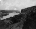
| Date: | 02 02 1927 |
|---|---|
| Description: | Elevated view of a cliff side overlooking a river. Caption reads: "Eagle Cliff, or Second Peak, in Perrot State Park. Donor Dr. Eben Pierce. Near Trempeale... |
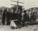
| Date: | 09 06 1926 |
|---|---|
| Description: | Group portrait of attendees at a ceremony to place a marker on the former site of the French post of Nicolas Perrot. From left to right are Dr. Eben D. Pie... |
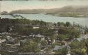
| Date: | 1920 |
|---|---|
| Description: | Text on front reads: "Trempealeau, Wis., on-the-Mississippi." Aerial view of the town on the Mississippi River. |

| Date: | 1921 |
|---|---|
| Description: | Text on front reads: "Village Hall, Whitehall, Wis." Built in 1912 of brick in the Romanesque Revival style. A memorial sign of honoring veterans, and a la... |
If you didn't find the material you searched for, our Library Reference Staff can help.
Call our reference desk at 608-264-6535 or email us at: