 Filter: Categories of Wisconsin Historical Images
Filter: County of St. Croix
Filter: Subject of roads
Filter: Categories of Wisconsin Historical Images
Filter: County of St. Croix
Filter: Subject of roads
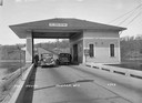
| Date: | 1937 |
|---|---|
| Description: | Toll House in Hudson showing two cars passing through. Caption reads: "Toll House, Hudson, Wis." |
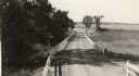
| Date: | 1918 |
|---|---|
| Description: | Amery Road near New Richmond. The photograph was taken by the Wisconsin Good Roads Association probably as an illustration of the kind of improved roads t... |
| Date: | 1899 |
|---|---|
| Description: | View of a marching band parading beneath a decorated arch on Main Street. Onlookers line both sides of the street. American flags are flying over the road ... |
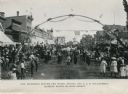
| Date: | 04 29 1942 |
|---|---|
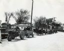
| Description: | Man pulling a trailer with an International truck for J.G. Larson & Sons, an International Harvester dealership. The trailer is loaded with two old tractor... |
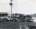
| Date: | 1942 |
|---|---|
| Description: | Men hauling wagon loads of scrap metal with a Farmall H tractor, horses, and an automobile. The men are participating in a scrap drive, possibly during Gov... |
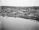
| Date: | 06 12 1899 |
|---|---|
| Description: | Elevated view over water, perhaps Hatfield Lake, of damage to houses and property caused by a tornado. Groups of people are scattered throughout the town. |
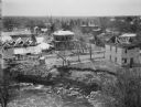
| Date: | 06 12 1899 |
|---|---|
| Description: | View over water, perhaps Hatfield Lake, of houses damaged and demolished in a tornado. Floating at the edge of the lake near an eroded bank are numerous pi... |
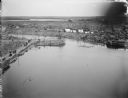
| Date: | 06 12 1899 |
|---|---|
| Description: | Elevated view over water of the damage created by a tornado. A river, with debris visibly floating in it, runs through the town. Groups of people are walki... |
| Date: | 1942 |
|---|---|
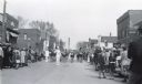
| Description: | A high school band marches down the street during MacArthur Week, a state sponsored scrap drive effort. Crowds of children and adults line both sides of th... |
| Date: | 1942 |
|---|---|
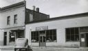
| Description: | View from across street of the Larson-Wiler Implement Company, an International Harvester dealership. |

| Date: | 1876 |
|---|---|
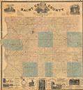
| Description: | This 1876 map of Saint Croix County, Wisconsin, shows the township and range grid, sections, towns, cities and villages, land ownership and acreages, wagon... |
| Date: | 1886 |
|---|---|
| Description: | This 1886 map of Saint Croix County, Wisconsin, shows the township and range grid, sections, towns, cities and villages, land ownership and acreages, wagon... |

| Date: | 1890 |
|---|---|
| Description: | This late 19th century map shows mining companies' lands and miscellaneous properties in the towns of Cady and Springfield in southeastern Saint Croix Coun... |

| Date: | 1913 |
|---|---|
| Description: | This early 20th century map of Saint Croix County, Wisconsin, shows the township and range grid, sections, towns, villages, roads, railroads, and lakes and... |
| Date: | 1928 |
|---|---|
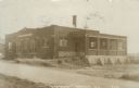
| Description: | Photographic postcard view across road of the creamery. The entrance is on the left and a loading dock is on the right. Caption reads: "'Creamery,' Baldwin... |
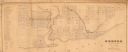
| Date: | 1850 |
|---|---|
| Description: | This map shows a plat of city, land ownership by name, local streets, roads, and part of Willow River and Lake St. Croix. The map is indexed by additions a... |

| Date: | |
|---|---|
| Description: | View of a steel highway bridge spanning Lake St. Croix. Caption reads: "New Bridge, Hwy. 12, Over Lake St. Croix, Hudson, Wis." |
If you didn't find the material you searched for, our Library Reference Staff can help.
Call our reference desk at 608-264-6535 or email us at: