Filter: Categories of Wisconsin Historical Images
Filter: County of Sheboygan
Filter: Year of 1800-1899
Filter: Categories of Wisconsin Historical Images
Filter: County of Sheboygan
Filter: Year of 1800-1899
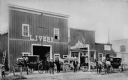
| Date: | 1892 |
|---|---|
| Description: | Men posed in front of a livery barn and horse sales stable. |
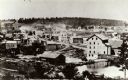
| Date: | 1868 |
|---|---|
| Description: | A view taken from the elevation on the south side of the Mullet River. |

| Date: | 1898 |
|---|---|
| Description: | Miss Graumann, far left, poses with four dressmakers in front of her shop. A sign on the right side of the door states "Dressmaking, Miss Annie Graumann".... |
| Date: | 1890 |
|---|---|
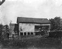
| Description: | A view of Rudolph Herrling's sawmill and log yard in front of the Herling farm. |
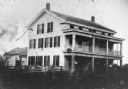
| Date: | 1860 |
|---|---|
| Description: | The oldest known image of the Wade House (taken from Ambrotype) with the Sheboygan/Fond du Lac Plank Road in the foreground. |

| Date: | 1857 |
|---|---|
| Description: | This map of Sheboygan Harbor shows the river mouth and harbor, piers, wharfs, piles of old destroyed bridge wharfs, streets, and the lake shore from survey... |

| Date: | 1836 |
|---|---|
| Description: | This 1836 map consists chiefly of a detailed map of the the mouth of the Sheboygan River. An inset map of the region and cross section diagrams of the pier... |

| Date: | 1862 |
|---|---|
| Description: | This 1862 map of Sheboygan County, Wisconsin, shows land ownership and acreages, the township and range grid, towns, cities and villages, roads, railroads,... |

| Date: | 1898 |
|---|---|
| Description: | This map shows the contour depths of Elkhart Lake in the Town of Rhine, Sheboygan County, Wisconsin, and includes two cross sections of the lake. The villa... |
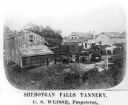
| Date: | 1878 |
|---|---|
| Description: | Elevated view of several buildings making up the Sheboygan Falls Tannery, which was owned by proprietor C.S. Weisse. Weisse is at the far right, standing w... |

| Date: | 1862 |
|---|---|
| Description: | Shows townships and sections, landownership and acreage, roads, railroads, churches, schools, and cemeteries. Inset maps: Plat of Hingham -- Plat of Casca... |
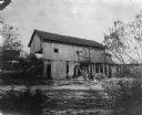
| Date: | 1890 |
|---|---|
| Description: | Herling Saw Mill and Dam Southeast elevation. |

| Date: | 1840 |
|---|---|
| Description: | This is a plat map of Sheboygan showing the Sheboygan River and Lake Michigan. Streets are labeled and plats are numbered in quadrants. Some points of inte... |

| Date: | 06 1899 |
|---|---|
| Description: | Two men and a woman pose on a wooden sidewalk in front of a bicycle livery with three bicycles. An awning is folded above the storefront, and signs and mer... |
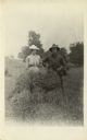
| Date: | 1890 |
|---|---|
| Description: | A young woman and man pose behind a hayrick in a farm field. They both wear hats. |

| Date: | 1893 |
|---|---|
| Description: | This map shows wards, railroads, street cars, streets, lot and block numbers, landownership, parks, hospitals, the Sheboygan River, and Lake Michigan. Ward... |

| Date: | 1865 |
|---|---|
| Description: | This map shows the harbor with proposed extensions and the shore line as it appeared in 1865. Depths are shown by soundings. |

| Date: | 1857 |
|---|---|
| Description: | This map shows piers, wharves, streets, and the lake shore from the survey of August 1856. Lake Michigan and the Sheboygan River are labeled. Depths are sh... |

| Date: | 1898 |
|---|---|
| Description: | View of a horse-drawn float decorated with banners and flags and rows of pharmaceuticals on shelves. Two costumed children are posing in the back. A large ... |
If you didn't find the material you searched for, our Library Reference Staff can help.
Call our reference desk at 608-264-6535 or email us at: