 Filter: Categories of Wisconsin Historical Images
Filter: County of Sheboygan
Filter: Subject of cities and towns
Filter: Categories of Wisconsin Historical Images
Filter: County of Sheboygan
Filter: Subject of cities and towns

| Date: | 1959 |
|---|---|
| Description: | This map shows some land ownership, lot and block numbers, additions, fair grounds, streets, and railroads and is indexed. Mullet River and Mill Pond are l... |

| Date: | 1961 |
|---|---|
| Description: | This map shows wards as well as proposed future streets, lot and block numbers, additions, and some landownership. The Sheboygan River is labeled. |

| Date: | 1857 |
|---|---|
| Description: | This map shows piers, wharves, streets, and the lake shore from the survey of August 1856. Lake Michigan and the Sheboygan River are labeled. Depths are sh... |
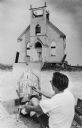
| Date: | 09 06 1968 |
|---|---|
| Description: | View of the front wall left standing of the Trinity Lutheran Church. A man in the foreground us painting a portrait of the church. The artist is identified... |

| Date: | 1926 |
|---|---|
| Description: | This blueprint map shows the Sheboygan River, buildings, and roads in the vicinity of the harbor. The map has explanations including "dredging required to ... |

| Date: | 1926 |
|---|---|
| Description: | This map includes a legend in the lower right corner of building heights. Districts marked "A" are 35 foot, districts marked "B" are 45 foot, districts mar... |

| Date: | 1926 |
|---|---|
| Description: | This map includes a legend in the lower right corner of land use. Districts are shown in five different shading for: "A" residential, "B" are residential, ... |

| Date: | 1940 |
|---|---|
| Description: | This map hows block and lot numbers, water mains, roads, parks, the Sheboygan River and some landownership. |

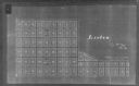
| Date: | 1894 |
|---|---|
| Description: | This map shows railroads, street railways, ward lines, land parcels, streets, schools and public buildings. Ward lines are highlighted in red. Lake Michiga... |
| Date: | 1900 |
|---|---|
| Description: | This map shows the paper city situated at the mouth of the Memee (Pigeon) River in Sheboygan County, just north of Sheboygan. Land parcels, streets, and ri... |

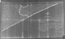
| Date: | 1939 |
|---|---|
| Description: | This map originally dated March 18, 1920 and revised for this edition. The map shows the original meander line of 'Shebowegan Lake' established by 1850 sur... |
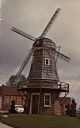
| Date: | |
|---|---|
| Description: | Because of the predominate Dutch background of people in the Cedar Grove area, it was decided by the Cedar Grove Booster Club to perpetuate this heritage w... |
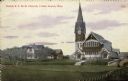
| Date: | 03 03 1910 |
|---|---|
| Description: | Hand-colored view of the Dutch R.F.M.D. Church. View across field or lawn. There is a dwelling and stable to the left of the church, and another building i... |
| Date: | 1900 |
|---|---|
| Description: | Map showing a paper city located in section 31 of T.16N, R.20E (now in Sheboygan County, Wisconsin). The back of the map includes registration and certific... |
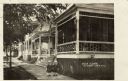
| Date: | |
|---|---|
| Description: | A home with a screened-in porch at the end of a row of houses. Young twins are standing on the sidewalk in front. Caption reads: "Villa Clara, Elkhart Lake... |
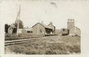
| Date: | 1908 |
|---|---|
| Description: | View alongside railroad tracks towards the railroad depot. A single freight car is on the tracks. A boy and a woman are on the platform. Caption reads: "De... |
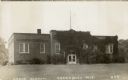
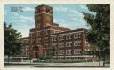
| Date: | |
|---|---|
| Description: | Black and white photographic postcard of an ivy-covered school building. A flagpole is on the roof. Caption reads: "Grade School, Greenbush, Wis." |

| Date: | |
|---|---|
| Description: | Elevated view of the expansive Kohler Plant and surrounding landscape. Caption reads: "Bird's-Eye View of Kohler Plant, Kohler, Wis." |
| Date: | |
|---|---|
| Description: | View of the administrative building at the Kohler Plant. Caption reads: "General Office, Kohler Co., Kohler, Wis." |

| Date: | |
|---|---|
| Description: | Text on reverse reads: "Waelderhaus, the Girl Scout House of Kohler, Wisconsin, U.S.A. is characteristic of architecture in the Bregenzerwald, Vorariberg, ... |
If you didn't find the material you searched for, our Library Reference Staff can help.
Call our reference desk at 608-264-6535 or email us at: