Filter: Categories of Wisconsin Historical Images
Filter: County of Sawyer
Filter: Year of 1900-1999
Filter: Year of 1920-1929
Filter: Categories of Wisconsin Historical Images
Filter: County of Sawyer
Filter: Year of 1900-1999
Filter: Year of 1920-1929
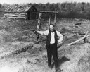
| Date: | 05 1924 |
|---|---|
| Description: | John F. Deitz holding a Luger pistol on a visit to Cameron Dam. |
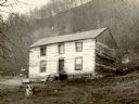
| Date: | 1925 |
|---|---|
| Description: | King house, owned by Joseph King, on a high bank above the Chippewa River near western end of Dead Lake. According to King, the house was formerly a tavern... |
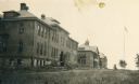
| Date: | 1920 |
|---|---|
| Description: | View of the Hayward Indian School, including the boys' building, chapel and schoolrooms, and the girls' building. |
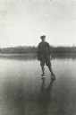
| Date: | 1922 |
|---|---|
| Description: | A young man, probably George Mattis, Jr., posing wearing ice skates on a frozen lake (possibly Knuteson Lake). |

| Date: | 05 17 1923 |
|---|---|
| Description: | Bottom Row: Walter Fedde, Earl Carls, George Botsford, Clifford Hunnicutt, Elmer Anderson, Bennie ?, Cornelius Corneliuson, Buddie Sileshy, and Victor ?. S... |

| Date: | 1923 |
|---|---|
| Description: | This map from the Wisconsin Lakes and Parks Association shows the area of a proposed state park, much of which is now part of the Flambeau River State Fore... |

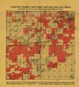
| Date: | 1920 |
|---|---|
| Description: | This map of Sawyer County, Wisconsin, from the early 20th century shows the township and range system, towns, sections, cities and villages, railroads, hig... |

| Date: | 1925 |
|---|---|
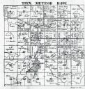
| Description: | This 1925 map of the northern portion of Sawyer County, Wisconsin, shows the township and range system, sections, roads, railroads, and lakes and streams i... |

| Date: | 1926 |
|---|---|
| Description: | This 1926 map of Sawyer County, Wisconsin, the township and range system, towns, sections, cities and villages, railroads, highways and roads, and lakes an... |

| Date: | 1927 |
|---|---|
| Description: | This 1927 map of Sawyer County, Wisconsin, shows the township and range system, sections, cities and villages, roads, railroads, and lakes and streams. |
| Date: | 1920 |
|---|---|
| Description: | This early-20th century map of the towns of Round Lake and Spider Lake, Sawyer County, Wisconsin, shows sections, roads, lake and streams, and land owned a... |
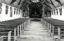
| Date: | 1924 |
|---|---|
| Description: | Postcard of the church interior, with pews, altar, nave, statues, and paintings. The church ceiling is decorated with garlands and wreaths. Caption reads: ... |

| Date: | 1920 |
|---|---|
| Description: | Two men are standing on either side of a saloon bar. The bartender on the right is identified as John Carlson. The bar has a stamped tin ceiling, and there... |
If you didn't find the material you searched for, our Library Reference Staff can help.
Call our reference desk at 608-264-6535 or email us at: