Filter: Categories of Wisconsin Historical Images
Filter: County of Sawyer
Filter: Creator Name of Unknown
Filter: Subject of transportation
Filter: Categories of Wisconsin Historical Images
Filter: County of Sawyer
Filter: Creator Name of Unknown
Filter: Subject of transportation
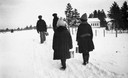
| Date: | |
|---|---|
| Description: | Winter scene with children bundled-up against the cold carrying their lunch pails down a snowy rural path to the one room school house called the Pahquahah... |
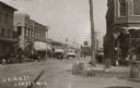
| Date: | 1883 |
|---|---|
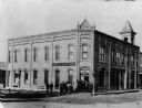
| Description: | View across intersection towards the Sawyer County Bank, with a group of people posed near its corner doorway. The Sawyer County Bank was organized on Marc... |
| Date: | 1912 |
|---|---|
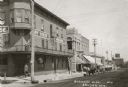
| Description: | View of the Sawyer business district with a bank visible in the foreground. |
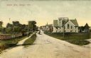
| Date: | |
|---|---|
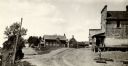
| Description: | View down unpaved road towards several buildings. |

| Date: | 1900 |
|---|---|
| Description: | Perspective drawing of the buildings at the Hayward Indian School. There is a man in a boat in the right foreground and an empty boat in the left foregroun... |
| Date: | |
|---|---|
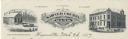
| Description: | Memohead of the Sawyer County Bank, of Hayward, Wisconsin, with the name of the bank in a banner, flanked by two images: a three-quarter view of the Real E... |
| Date: | 1910 |
|---|---|
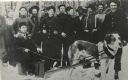
| Description: | Group portrait of loggers in a lumber camp. In front, seated on his sled, is T.J. Thompson. He traveled among the lumber camps between Winter and Raddison,... |
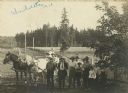
| Date: | 1910 |
|---|---|
| Description: | Uhrenholdt family on the family farm in Seeley. |

| Date: | 1897 |
|---|---|
| Description: | This 1897 map of Sawyer County, Wisconsin, shows the township and range system, sections, roads, farm houses, camps, school houses, dams, bridges, Indian r... |

| Date: | 1898 |
|---|---|
| Description: | This 1898 map of Sawyer County, Wisconsin, shows the township and range system, sections, roads, farm houses, camps, school houses, dams, bridges, Indian r... |

| Date: | 1900 |
|---|---|
| Description: | This map of Sawyer County, Wisconsin, shows the numbered "sub-school-districts of the town of Hayward" school houses, and the Indian reservation. The towns... |

| Date: | 1902 |
|---|---|
| Description: | This 1902 map of the eastern portion of Sawyer County, Wisconsin, shows the township and range system, sections, roads, farm houses, camps, school houses, ... |

| Date: | |
|---|---|
| Description: | This map shows the township and range system, sections, dam locations, railroads, roads, selected buildings, and lakes and streams in Sawyer County, Wiscon... |

| Date: | 1970 |
|---|---|
| Description: | This map shows lot and block numbers, city limits, cemeteries, schools, outdoor theater, Lumberjack Bowl, and Historyland among other attractions. |
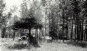
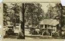
| Date: | 1932 |
|---|---|
| Description: | An early view of the Ojibwa Roadside Park. There are several automobiles in the background, and people sit on benches under the trees. |
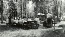
| Date: | 1940 |
|---|---|
| Description: | A group of people having a picnic at the Ojibwa Roadside Park. There are several cars and trucks in the background, and a small building. The picnic tables... |
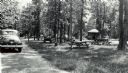
| Date: | 1940 |
|---|---|
| Description: | Several small groups of people are scattered about the roadside park among picnic tables. There are parked automobiles, and a small building. |
If you didn't find the material you searched for, our Library Reference Staff can help.
Call our reference desk at 608-264-6535 or email us at: