 Filter: Categories of Wisconsin Historical Images
Filter: County of Sauk
Filter: Year of 1800-1899
Filter: Categories of Wisconsin Historical Images
Filter: County of Sauk
Filter: Year of 1800-1899

| Date: | 1892 |
|---|---|
| Description: | A Sanborn fire insurance map of Sauk City which was drawn up in 1892. |

| Date: | 1870 |
|---|---|
| Description: | A stereograph of a bearded man, seen in profile, and a woman, looking directly at the camera, posing near a picket fence. There is a small wood frame house... |
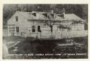
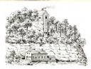
| Date: | 1846 |
|---|---|
| Description: | A wooden building enclosed by a fence. Caption on rear of photograph reads: First Church In Sauk-Prairie-Roxbury Region - 1846. Reproduction of an early ph... |
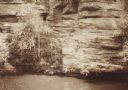
| Date: | 1885 |
|---|---|
| Description: | Elevated view over water towards an elderly man using a long pole to fish from a steep rock ledge on the opposite shoreline. |
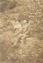
| Date: | 1898 |
|---|---|
| Description: | Man and woman seated on an overgrown hillside. The woman has ferns on her lap and is holding an umbrella. Inscribed on reverse of original mount: "B.D.L. a... |

| Date: | 1890 |
|---|---|
| Description: | A large class stands outside a school. Front row, left to right: Stella Nuzum, unknown, unknown, unknown, Mabel Devlin, Mary Devlin, unknown, Alice Odekirk... |
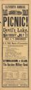
| Date: | 1889 |
|---|---|
| Description: | An original poster advertising the eleventh annual railroad picnic, taking place at Devil's Lake State Park on Saturday, July 27, 1889. In the advertiseme... |
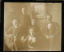
| Date: | 1894 |
|---|---|
| Description: | A group portrait including Dr. Edward A. Bass, seated on the far right, next to his parents, Isaac W. and Lorinda Hill Bass. Dr. Bass's brother Frank Bas... |
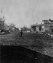
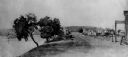
| Date: | 1875 |
|---|---|
| Description: | View of the west side of Water Street. |
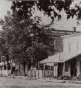
| Date: | 1868 |
|---|---|
| Description: | View of Water Street looking north from the business district. |
| Date: | 1878 |
|---|---|
| Description: | Cliff House, a resort hotel built shortly after 1872 when Devil's Lake was reached by rail. Three-story frame house with balcony on each floor. There is a ... |
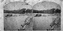
| Date: | 1878 |
|---|---|
| Description: | Lake shore with men and railroad tracks on Devil's Lake. |
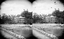
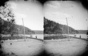
| Date: | 1874 |
|---|---|
| Description: | View west from the Cliff House at Devil's Lake. |

| Date: | 1870 |
|---|---|
| Description: | Sauk City is the oldest incorporated village in Wisconsin (incorporated in 1854) and also has the oldest organized volunteer fire department in the state, ... |

| Date: | 1874 |
|---|---|
| Description: | Bird's-eye map of Reedsburg, on the Baraboo River. |
| Date: | 1850 |
|---|---|
| Description: | Buildings along Wisconsin River. |
| Date: | 1836 |
|---|---|
| Description: | The shot tower at Tower Hill State Park. |

| Date: | 01 01 1852 |
|---|---|
| Description: | These manuscript maps, drawn by William H. Canfield in 1852, illustrate mounds primarily in Sauk County, Wisconsin, in the towns of Greenfield, La Valle, M... |

| Date: | 1870 |
|---|---|
| Description: | Bird's-eye map of Prairie du Sac. |
If you didn't find the material you searched for, our Library Reference Staff can help.
Call our reference desk at 608-264-6535 or email us at:
