 Filter: Categories of Wisconsin Historical Images
Filter: County of Sauk
Filter: Subject of recreation
Filter: Subject of rivers
Filter: Categories of Wisconsin Historical Images
Filter: County of Sauk
Filter: Subject of recreation
Filter: Subject of rivers
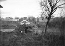
| Date: | 1918 |
|---|---|
| Description: | View of the Ringling Brothers Circus winter quarters from across the Baraboo River, looking due north. The brick building, center, was one of the two "Cat ... |

| Date: | 1950 |
|---|---|
| Description: | Map showing buildings formerly used as Ringling Brothers Circus winter quarters, along with adjoining buildings. |
| Date: | |
|---|---|
| Description: | A view of a valley possibly in or around Devil's Lake. A man is visible in the foreground, hiking up the steep incline of the valley. |

| Date: | 1940 |
|---|---|
| Description: | This pictorial map shows points of interest, recreation activities, and highways in the vicinity of the restaurant and covers the Wisconsin River Valley be... |
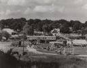
| Date: | 1960 |
|---|---|
| Description: | Elevated view from hill looking north, showing the grounds of the Circus World historic site, with visiting crowd. On display are several train cars and wa... |

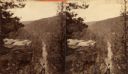
| Date: | 1901 |
|---|---|
| Description: | Stereograph of a formation on the Wisconsin River called "The Ink Stand." On the shore a woman is sitting on a wooden bench, and behind her is a picnic bas... |

| Date: | 08 25 1910 |
|---|---|
| Description: | Text on front reads: "Baraboo, Wis. Boat Landing, Baraboo River." A man in a boat on the river, trees, cottages and piers are on the shorelines. Text on re... |
If you didn't find the material you searched for, our Library Reference Staff can help.
Call our reference desk at 608-264-6535 or email us at: