 Filter: Categories of Wisconsin Historical Images
Filter: County of Sauk
Filter: Subject of land use
Filter: Subject of indians of north america
Filter: Categories of Wisconsin Historical Images
Filter: County of Sauk
Filter: Subject of land use
Filter: Subject of indians of north america

| Date: | 1954 |
|---|---|
| Description: | Raddatz Rockshelter and Natural Bridge, known by archaeologists as 47 SK-5. The bridge is made of sand stone, reaching 35 feet in height, and is the larges... |
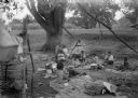
| Date: | 1925 |
|---|---|
| Description: | A Native American (possibly Ho-Chunk) family rests at their campsite under a large tree. There is a bucket suspended over a small campfire. |
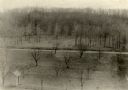
| Date: | |
|---|---|
| Description: | Elevated view of Man Mound outlined in chalk looking south. A road bisects the legs of the effigy mound. A small outbuilding can be seen at left in the for... |
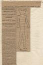
| Date: | 12 28 1906 |
|---|---|
| Description: | Newspaper article about the purchase of land for a park related to Man Mound in Sauk County accompanied by a line drawing of the mound. Article clipped fro... |

| Date: | 01 01 1852 |
|---|---|
| Description: | These manuscript maps, drawn by William H. Canfield in 1852, illustrate mounds primarily in Sauk County, Wisconsin, in the towns of Greenfield, La Valle, M... |
| Date: | 1936 |
|---|---|
| Description: | An elevated view towards a Native American man wearing a feathered headdress and a young girl of European descent standing in front of a tepee on the stage... |
If you didn't find the material you searched for, our Library Reference Staff can help.
Call our reference desk at 608-264-6535 or email us at: