Filter: Categories of Wisconsin Historical Images
Filter: County of Sauk
Filter: Subject of land
Filter: Subject of roads
Filter: Categories of Wisconsin Historical Images
Filter: County of Sauk
Filter: Subject of land
Filter: Subject of roads
| Date: | 1903 |
|---|---|
| Description: | Horse-drawn vehicle on Canyon Trail at Mirror Lake. |

| Date: | 1870 |
|---|---|
| Description: | Baraboo was first settled around 1838, and by 1870 it had become the county seat and the thriving village illustrated here. This birds eye drawing depicts ... |

| Date: | 1870 |
|---|---|
| Description: | Bird's-eye map of Prairie du Sac. |

| Date: | 1870 |
|---|---|
| Description: | Sauk City is the oldest incorporated village in Wisconsin (incorporated in 1854) and also has the oldest organized volunteer fire department in the state, ... |

| Date: | 1883 |
|---|---|
| Description: | Bird's-eye map of Prairie du Sac, Wisconsin with an inset of Clifton. |
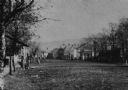
| Date: | 1875 |
|---|---|
| Description: | View of unpaved Water Street south of the Highway 12 intersection, looking north. Bluffs are in the distance. |
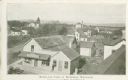
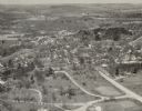
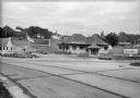
| Date: | 1900 |
|---|---|
| Description: | Elevated view of commercial buildings, houses, a church and a school in a neighborhood. In the foreground a person is standing at the side of a building wi... |

| Date: | 1925 |
|---|---|
| Description: | View down center of the Wisconsin River bridge. |
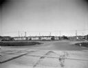
| Date: | 1920 |
|---|---|
| Description: | Loganville Road in Sauk County taken by the Wisconsin Good Roads Association. The photograph was meant to create a contrast between the new improved road ... |
| Date: | 1925 |
|---|---|
| Description: | View from across road of the Devil's Barbecue roadside restaurant on South Boulevard, then Highway 12, near Baraboo. The restaurant is a stone building; th... |
| Date: | 1945 |
|---|---|
| Description: | View from road of vines and flower boxes brightening an otherwise unremarkable row of barracks type housing. There is an A & P Food Store on the right, wit... |

| Date: | |
|---|---|
| Description: | Elevated view from rocks overlooking a valley toward Devil's Lake. Several houses are near a road that leads to the shoreline. |

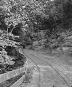
| Date: | 1929 |
|---|---|
| Description: | View of a man driving an automobile on a dirt road in Ableman. Rock formations are on both sides of the road, and rocks and trees are in the background. |

| Date: | |
|---|---|
| Description: | Map of Baraboo and its surroundings, showing the ancient mound city, the water power, and thoroughfares, drawn by William H. Canfield. Canfield includes sk... |

| Date: | 08 21 1952 |
|---|---|
| Description: | From left to right are Lewis, Nellie and Bernard Arms posing behind a convertible on Old Lake Road, with Bernard and Nellie's house in the background. |
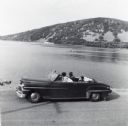
| Date: | 1956 |
|---|---|
| Description: | Lewis, LuRay, Nellie and Bernard Arms arrive at Devil's Lake in a maroon DeSoto convertible automobile. This was the day after Lewis and LuRay's wedding. |
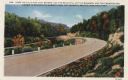
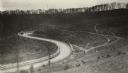
| Date: | 1933 |
|---|---|
| Description: | Colorized postcard of a paved road curving to the left through trees, shrubs and bluffs. A dirt road can be seen to the left, and the sky is blue with a fe... |

| Date: | 1914 |
|---|---|
| Description: | Colorized postcard of the rock formation called the Devil's Doorway in Devil's Lake State Park. Trees can be seen below. The lake, bluffs, roads and buildi... |

| Date: | 12 29 1909 |
|---|---|
| Description: | Colorized postcard of the rock formation called the Devil's Doorway in Devil's Lake State Park. Trees are on the left and below. Bluffs, trees, sky and a r... |
If you didn't find the material you searched for, our Library Reference Staff can help.
Call our reference desk at 608-264-6535 or email us at: