 Filter: Categories of Wisconsin Historical Images
Filter: County of Sauk
Filter: Subject of land
Filter: Subject of architecture
Filter: Categories of Wisconsin Historical Images
Filter: County of Sauk
Filter: Subject of land
Filter: Subject of architecture

| Date: | |
|---|---|
| Description: | View upriver towards dam. Buildings on shoreline at left. Sign on roof reads: "Mirror Lake Boats." |
| Date: | 06 1967 |
|---|---|
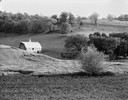
| Description: | Landscape with brilliantly lighted barn in last rays of sunlight. |

| Date: | 1870 |
|---|---|
| Description: | Baraboo was first settled around 1838, and by 1870 it had become the county seat and the thriving village illustrated here. This birds eye drawing depicts ... |

| Date: | 1870 |
|---|---|
| Description: | Bird's-eye map of Prairie du Sac. |

| Date: | 1870 |
|---|---|
| Description: | Sauk City is the oldest incorporated village in Wisconsin (incorporated in 1854) and also has the oldest organized volunteer fire department in the state, ... |

| Date: | 1883 |
|---|---|
| Description: | Bird's-eye map of Prairie du Sac, Wisconsin with an inset of Clifton. |
| Date: | 1909 |
|---|---|
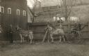
| Description: | Two men sit in a two-wheeled buggy hooked up to zebras, next to a fence near the Ring Barn on the left (which is still standing), with several male spectat... |
| Date: | 1878 |
|---|---|
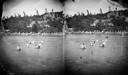
| Description: | Swimming in the lake with the Cliff House in background. Cliff House was a resort hotel built shortly after 1872, when Devil's Lake was reached by rail. Bo... |
| Date: | |
|---|---|
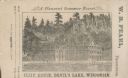
| Description: | View of the Cliff House on the lake, with pine trees surrounding the property, and a cliff behind the building. |
| Date: | 1909 |
|---|---|
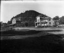
| Description: | A mill, left, and a commercial building with attached residence stand in front of a wooded bluff. A woman crosses a small bridge near the mill. |
| Date: | 1950 |
|---|---|
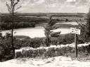
| Description: | A view from a bluff on Tower HIll overlooking the Wisconsin River. A sign on the right reads: "Shot Shaft". |
| Date: | 1945 |
|---|---|
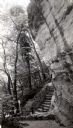
| Description: | Tower Hill State Park trail leading to the top of the shot tower shaft. |

| Date: | 1859 |
|---|---|
| Description: | Map featuring various views of buildings and scenes from Sauk County. |
| Date: | 1896 |
|---|---|
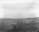
| Description: | Elevated view. Caption on negative sleeve reads: "Black Hawk Battlefield. Wis. Heights. Looking N. of E. up valley towards Catholic Church. Mrs. Charles N.... |
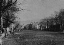
| Date: | 1875 |
|---|---|
| Description: | View of unpaved Water Street south of the Highway 12 intersection, looking north. Bluffs are in the distance. |
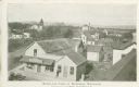
| Date: | 1900 |
|---|---|
| Description: | Elevated view of commercial buildings, houses, a church and a school in a neighborhood. In the foreground a person is standing at the side of a building wi... |
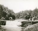
| Date: | 1930 |
|---|---|
| Description: | View of the mill dam on Dell Creek that creates Mirror Lake in Mirror Lake State Park (although the photograph was taken before the site was designated as ... |
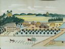
| Date: | 1875 |
|---|---|
| Description: | Seifert's watercolor is fairly large, measuring 27" wide by 21" high, and provides a detailed depiction of a nineteenth century Wisconsin farm. The small s... |
| Date: | |
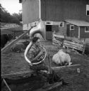
|---|---|
| Description: | Member of a local farmers band practicing the tuba in a barnyard with cows. In the background is a barn on a hill. |
| Date: | 03 1911 |
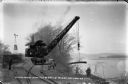
|---|---|
| Description: | Workers use a rail car mounted crane to load pilings onto a barge. Bluffs are in the distance. |
If you didn't find the material you searched for, our Library Reference Staff can help.
Call our reference desk at 608-264-6535 or email us at: