Filter: Categories of Wisconsin Historical Images
Filter: County of Rock
Filter: Type of Map or Atlas
Filter: Year of 1800-1899
Filter: Categories of Wisconsin Historical Images
Filter: County of Rock
Filter: Type of Map or Atlas
Filter: Year of 1800-1899

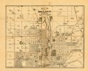
| Date: | 1890 |
|---|---|
| Description: | Bird's-eye map of Beloit with insets of Williams Engine Works, Eclipse Wind Engine Co., and John Foster & Co. Turtle Creek is in the lower section, and the... |

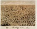
| Date: | 1874 |
|---|---|
| Description: | Bird's-eye view of Beloit, with insets of Beloit College, Beloit High School, and Memorial Hall. |

| Date: | 1877 |
|---|---|
| Description: | Bird's-eye map of Janesville on the Rock River. |

| Date: | 1881 |
|---|---|
| Description: | Bird's-eye map of Milton Junction. |

| Date: | 1871 |
|---|---|
| Description: | Like many southeastern Wisconsin villages, Edgerton was settled by Yankee immigrants in the 1830s. Though this view gives no indication of it, by 1871 toba... |

| Date: | 1858 |
|---|---|
| Description: | This 1858 map of Rock County, Wisconsin, shows the township and range grid, towns, sections, cities and villages, railroads, roads, property owners and res... |

| Date: | 1853 |
|---|---|
| Description: | Map covers area between the cities of Janesville and Kenosha in Rock, Walworth, and Kenosha counties for railroad routes. Lakes and counties are labelled. ... |

| Date: | 1800 |
|---|---|
| Description: | This map on two sheets shows a group of ancient mounds near the southeast corner of the city of Beloit and a group of ancient mounds north of Rockton Stati... |
| Date: | 1887 |
|---|---|
| Description: | This map of Beloit shows labeled wards, plat of town, roads, railroads, the Rock River, city boundaries, and land ownership by name. The back of the map is... |

| Date: | 1860 |
|---|---|
| Description: | Map showing a plat of the city, land ownership by name, wards by number, local streets, buildings, fair grounds, nurseries, and part of Rock River. The map... |

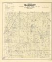
| Date: | 1873 |
|---|---|
| Description: | This map shows landownership and acreages, lot and block numbers, roads and railroads, marshes, schools, churches, mills, rural buildings, and quarries. Re... |

| Date: | 1850 |
|---|---|
| Description: | This map shows a plat of the town, land owners by name, local streets, railroads, churches, and part of the Rock River. The map is also indexed by church d... |

| Date: | 1873 |
|---|---|
| Description: | This map shows land ownership by name, local streets, railroads, parks, college grounds, schools, cemeteries, and part of Rock River. The upper left margin... |

| Date: | 1836 |
|---|---|
| Description: | This map is ink on tracing paper and shows block numbers, streets, lot numbers of block no. 6, and a public square in Newburgh, a paper city (a city planne... |
If you didn't find the material you searched for, our Library Reference Staff can help.
Call our reference desk at 608-264-6535 or email us at: