 Filter: Categories of Wisconsin Historical Images
Filter: County of Price
Filter: Subject of education
Filter: Categories of Wisconsin Historical Images
Filter: County of Price
Filter: Subject of education
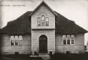
| Date: | 1900 |
|---|---|
| Description: | View of the front of the public school established in 1896. Caption reads: "Public School, Park Falls, Wis." |

| Date: | 1910 |
|---|---|
| Description: | Park Hotel from a clipping taken from the Park Falls Herald of April 5, 1962. The caption reads: "Park Hotel was a landmark in the early days of Park Falls... |

| Date: | 1905 |
|---|---|
| Description: | Exterior view of the high school. Caption reads: "High School, Park Falls, Wis." |
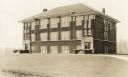
| Date: | |
|---|---|
| Description: | Three-story brick building with two entrances, windows, and a hip roof. Signs above both entrances says: County Normal. |

| Date: | |
|---|---|
| Description: | Conservationist Sigurd Olson (front row, left) posing with his class, probably at Prentice, Wisconsin. |

| Date: | 1895 |
|---|---|
| Description: | The front (left) and back (right) of a promotional card advertising farming land in northern Wisconsin. The caption below the image reads: "A typical cou... |

| Date: | 1887 |
|---|---|
| Description: | This 1887 map of Price County, Wisconsin, shows the township and range system, sections, railroads, vacant land and land sold by the Wisconsin Central Rail... |

| Date: | 1914 |
|---|---|
| Description: | This map of Price County, Wisconsin, from the early 20th century shows land for sale by the Homemaker Land Company of Milwaukee. The township and range sys... |

| Date: | 1925 |
|---|---|
| Description: | This map of Price County, Wisconsin, from the early 20th century shows the township and range system, towns, sections, cities and villages, railroads, high... |

| Date: | 1888 |
|---|---|
| Description: | This late 19th century map of Price County, Wisconsin, shows landownership and waterfront acreages, the township and range system, towns, cities and villag... |

| Date: | 1910 |
|---|---|
| Description: | This map from the early 20th century shows the Wisconsin Central Railroad land grant lands owned and for sale by the Soo Line in Price County, Wisconsin, a... |

| Date: | 1914 |
|---|---|
| Description: | This 1914 map of Price County, Wisconsin, shows land for sale by the Good Land Company and Dewitt van Ostrand of Phillips. Also shown are the township and ... |

| Date: | 1925 |
|---|---|
| Description: | This map of Price County, Wisconsin, from the early 20th century shows the township and range system, towns, sections, cities and villages, railroads, high... |

| Date: | 1891 |
|---|---|
| Description: | This map shows vacant Southwick & Sellers lands, settlers' houses, Goodland Co. land, schools, churches, saw mills, roads, and railroads. A key in the uppe... |
If you didn't find the material you searched for, our Library Reference Staff can help.
Call our reference desk at 608-264-6535 or email us at: