 Filter: Categories of Wisconsin Historical Images
Filter: County of Price
Filter: Subject of church buildings
Filter: Categories of Wisconsin Historical Images
Filter: County of Price
Filter: Subject of church buildings
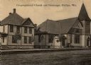
| Date: | 1900 |
|---|---|
| Description: | View across road towards the church. Caption reads: "Congregational Church and Parsonage, Phillips, Wis." |
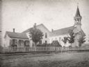
| Date: | 04 25 1931 |
|---|---|
| Description: | A view of a church and what appears to be the adjoining rectory. This is the Parish of St. Anthony in the town of Fifield. |

| Date: | 1925 |
|---|---|
| Description: | This map of Price County, Wisconsin, from the early 20th century shows the township and range system, towns, sections, cities and villages, railroads, high... |

| Date: | 1910 |
|---|---|
| Description: | This map from the early 20th century shows the Wisconsin Central Railroad land grant lands owned and for sale by the Soo Line in Price County, Wisconsin, a... |

| Date: | 1914 |
|---|---|
| Description: | This 1914 map of Price County, Wisconsin, shows land for sale by the Good Land Company and Dewitt van Ostrand of Phillips. Also shown are the township and ... |

| Date: | 1925 |
|---|---|
| Description: | This map of Price County, Wisconsin, from the early 20th century shows the township and range system, towns, sections, cities and villages, railroads, high... |

| Date: | 1891 |
|---|---|
| Description: | This map shows vacant Southwick & Sellers lands, settlers' houses, Goodland Co. land, schools, churches, saw mills, roads, and railroads. A key in the uppe... |
If you didn't find the material you searched for, our Library Reference Staff can help.
Call our reference desk at 608-264-6535 or email us at: