 Filter: Categories of Wisconsin Historical Images
Filter: County of Price
Filter: Creator Name of Unknown
Filter: Subject of transportation
Filter: Categories of Wisconsin Historical Images
Filter: County of Price
Filter: Creator Name of Unknown
Filter: Subject of transportation
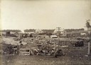
| Date: | 1895 |
|---|---|
| Description: | Railroad depot surrounded by stacked lumber for wood-burning locomotives. A few homes can be seen in the background. |
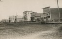
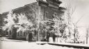
| Date: | 1885 |
|---|---|
| Description: | View across unpaved Main Street, with storefronts on the right, including a restaurant and meat market. Caption reads: "Main Street". |
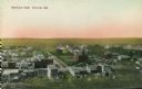
| Date: | 1905 |
|---|---|
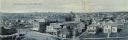
| Description: | Elevated view of town. Caption reads: "Bird's-Eye View, Phillips, Wis." |
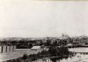
| Date: | 1890 |
|---|---|
| Description: | Elevated view of the town as it appeared before the fire of 1894. |
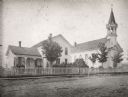
| Date: | 1900 |
|---|---|
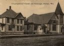
| Description: | View across road towards the church. Caption reads: "Congregational Church and Parsonage, Phillips, Wis." |
| Date: | 1910 |
|---|---|
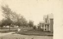
| Description: | View across road towards a neighborhood along another road. Houses are on the right, and two children in the center are standing on the sidewalk in the cen... |
| Date: | 1910 |
|---|---|
| Description: | Elevated panoramic view of the town. Caption reads: "Bird's-Eye View of Park Falls, Wis." |
| Date: | 1900 |
|---|---|
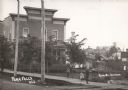
| Description: | View across road towards the Park Hotel, with children playing on the sidewalk in front of the hotel. Caption reads: "Park Falls, Wis." |
| Date: | 1900 |
|---|---|
| Description: | A view of the Park Hotel in winter. A man on the left is pulling a sled piled with firewood. |
| Date: | 04 25 1931 |
|---|---|
| Description: | A view of a church and what appears to be the adjoining rectory. This is the Parish of St. Anthony in the town of Fifield. |
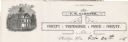
| Date: | |
|---|---|
| Description: | Letterhead of the Price County Treasurer's office, with a three-quarter view of the county building, and people walking and children playing outside. Text ... |

| Date: | 1910 |
|---|---|
| Description: | This map is ink on paper. Shows Bruce’s proposed railway route and Moon’s railroad survey route along the Flambeau River, in parts of Lake and Eisenstein t... |

| Date: | |
|---|---|
| Description: | Postcard advertising the Good Land Company with a photograph of a farm and information for "Homeseekers, Farmers and Investors." |

| Date: | 1903 |
|---|---|
| Description: | This blue line print map is oriented with the north to the left and shows buildings with dimensions, utilities, and proposed buildings. The Flambeau River ... |

| Date: | 1891 |
|---|---|
| Description: | This map shows vacant Southwick & Sellers lands, settlers' houses, Goodland Co. land, schools, churches, saw mills, roads, and railroads. A key in the uppe... |
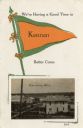
| Date: | |
|---|---|
| Description: | An illustration of a pennant, and a photograph of the town. |
If you didn't find the material you searched for, our Library Reference Staff can help.
Call our reference desk at 608-264-6535 or email us at: