Filter: Categories of Wisconsin Historical Images
Filter: County of Oneida
Filter: Subject of roads
Filter: Categories of Wisconsin Historical Images
Filter: County of Oneida
Filter: Subject of roads
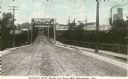
| Date: | 1905 |
|---|---|
| Description: | View down center of the Davenport Street Bridge with a paper mill in the distance on the right. Caption reads: "Davenport Street Bridge and Paper Mill, Rhi... |

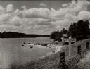
| Date: | |
|---|---|
| Description: | Near Lake Minocqua. View of rear of car driving on narrow dirt road lined with trees along lake which is on the right. A barn and silo are on the shoreline... |
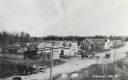
| Date: | 1897 |
|---|---|
| Description: | Lumbertown Street (Now Highway 47). There are horse-drawn carts and a car. Sailors burned down Lumbertown in 1897. It was later built up as a resort town.... |

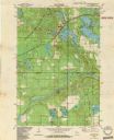
| Date: | 1915 |
|---|---|
| Description: | This 1915 map shows railroads, wagon roads, trails, creeks, rivers, lakes, and trout streams in Oneida and Lincoln counties within a 12 mile radius of Rhin... |
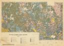
| Date: | 1959 |
|---|---|
| Description: | Map of soil in Oneida County. Bottom of the map includes a legend of soil; "SECOND CLASS SOILS GOOD TO FAIR FARM LAND" are represented in shades of yellow ... |

| Date: | 1900 |
|---|---|
| Description: | This map of Three Lakes shows forest fire lookout towers, picnic grounds, an airport, roads, and railroad. The map features text boxes on the Village of Th... |
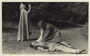
| Date: | |
|---|---|
| Description: | Three campers pose for a scene in a dramatic activity. They are dressed in costume. One camper stands, wearing a cape with a hood, gesturing with her left ... |

| Date: | 1900 |
|---|---|
| Description: | This map shows logging roads, railroads with spur lines, trails, rapids, lumber camps, Indian villages, summer resort, lakes, rivers, and ponds. |

| Date: | 1940 |
|---|---|
| Description: | This map shows lakes, roads, car trails, foot trails, railroads, resorts and camps, and fire towers. The map includes an inset location map and pictorial d... |

| Date: | |
|---|---|
| Description: | Long exposure at night of cars driving on the interstate near Highway X. |

| Date: | 1935 |
|---|---|
| Description: | View across snowy road towards men and women posing in front of Idlewild Lodge, a two-story wood framed structure with log siding on the first floor, and a... |
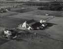
| Date: | 10 05 1948 |
|---|---|
| Description: | Aerial photograph of the Baumgartner Dairy Farm, one half mile east of Three Lakes, WI. |
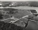
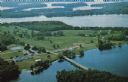
| Date: | 1950 |
|---|---|
| Description: | Aerial view of Northernaire Resort, on Deer Lake. The resort is in the foreground. Many lakes, surrounded by trees, are in the background, including Big St... |
| Date: | 1982 |
|---|---|
| Description: | This standard U.S.G.S. topographic map was annotated by civil engineer and railroad historian James P. Kaysen to show the location of existing and defunct ... |
| Date: | 1963 |
|---|---|
| Description: | Text on reverse reads: "Northernaire, Three Lakes, WI 54562. Phone 715 – 546-3331. The Resort Hotel that has it all." Aerial view of Northernaire Resort, o... |
If you didn't find the material you searched for, our Library Reference Staff can help.
Call our reference desk at 608-264-6535 or email us at: