 Filter: Categories of Wisconsin Historical Images
Filter: County of Oneida
Filter: Community of Rhinelander
Filter: Type of Map or Atlas
Filter: Categories of Wisconsin Historical Images
Filter: County of Oneida
Filter: Community of Rhinelander
Filter: Type of Map or Atlas

| Date: | 1923 |
|---|---|
| Description: | Map of Oneida County-Rhinelander Airport which was laid out at the county fairgrounds. The map appears on the reverse side of a letter Roy Larson received ... |

| Date: | 1915 |
|---|---|
| Description: | This 1915 map shows railroads, wagon roads, trails, creeks, rivers, lakes, and trout streams in Oneida and Lincoln counties within a 12 mile radius of Rhin... |
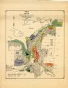
| Date: | 1956 |
|---|---|
| Description: | This map of Rhinelander shows lots, 6 types of zoning in various colors; heavy industry, light industry, commercial, residence "A," residence "unrated," lo... |

| Date: | |
|---|---|
| Description: | A plat map drawn in blue and red ink of township No. 43 North of Range No. 4 East of 4th Meridian. |
If you didn't find the material you searched for, our Library Reference Staff can help.
Call our reference desk at 608-264-6535 or email us at: