 Filter: Categories of Wisconsin Historical Images
Filter: County of Milwaukee
Filter: Year of 1800-1899
Filter: Year of 1830-1839
Filter: Categories of Wisconsin Historical Images
Filter: County of Milwaukee
Filter: Year of 1800-1899
Filter: Year of 1830-1839

| Date: | 1833 |
|---|---|
| Description: | Illustration of the Solomon Juneau fur trading post at Milwaukee in 1833. |
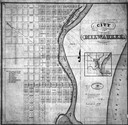
| Date: | 1836 |
|---|---|
| Description: | Map of Milwaukee including the Milwaukee River and Lake Michigan shore. |
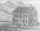
| Date: | 1836 |
|---|---|
| Description: | Drawing of the Solomon Juneau house on East Michigan. There are tethered bears on either side of the front door. Two people are leaning on the fence, watch... |
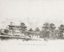
| Date: | 1839 |
|---|---|
| Description: | Courthouse and surrounding buildings. There are also two horse-drawn carriages, people on horseback, and a few pedestrians. |

| Date: | 1835 |
|---|---|
| Description: | Two-story home with sloping roof. One man is whipping a team of eight cattle while another man drives the plow behind them. To the left stands a man near a... |

| Date: | 1833 |
|---|---|
| Description: | Published in James Smith Buck's, "Pioneer History of Milwaukee". Lake Michigan is on the right, with three rivers that combine at different points and reac... |

| Date: | 1833 |
|---|---|
| Description: | Drawing on a faint grid with Lake Michigan on the right, and the rivers on the left. Labeled is an Indian Village, J. Veiu, S. Juneau, and P. Juneau. Alo... |

| Date: | 1836 |
|---|---|
| Description: | This hand-colored manuscript map shows the township and section grid in southeastern Wisconsin, covering the area west to Sugar River and Four Lakes region... |

| Date: | 1830 |
|---|---|
| Description: | A hand-drawn map of the township sectioning of Milwaukee, eastern Waukesha, northern Walworth, and Racine Counties. Other items shown in the map are the la... |

| Date: | 1837 |
|---|---|
| Description: | A pen and ink on tracing paper, hand-drawn and colored map the proposed route of the Milwaukee and Rock River Canal, ranging from the Rock River in the wes... |

| Date: | 1838 |
|---|---|
| Description: | A map of the proposed route of the Milwaukee and Rock River Canal from Fort Atkinson on the Rock River in the west to the city of Milwaukee and Lake Michig... |

| Date: | 1830 |
|---|---|
| Description: | An ink on paper, hand-drawn map of the town of Milwaukee, showing the divisions and landownership within the town by private individuals as well as those l... |

| Date: | 1835 |
|---|---|
| Description: | Shows Walker’s Point, Juneau Town and Kilbourn Town, including labeled buildings, trails and Indian villages. Relief shown by hachures. Oriented with north... |

| Date: | 1835 |
|---|---|
| Description: | This map is pen-and-ink on paper. The map shows landowners in "Milwalky" or present day Milwaukee. Includes "list of property offered to Mr. Walker". The m... |

| Date: | 1835 |
|---|---|
| Description: | Plat map of Milwaukee. Pen-and-ink and watercolor on paper. Certifications on back side signed by several early settlers, as well as a justice of the peace... |

| Date: | 1836 |
|---|---|
| Description: | Pencil on tracing paper. Rough sketch of Milwaukee. Left top corner reads: "From Map of northern part of Illinois and the surveyed part of Wisconsin Territ... |

| Date: | 1836 |
|---|---|
| Description: | This map shows settlers houses and businesses, trails, and swamps. The relief is shown by hachures. The map includes illustrations of historical buildings ... |

| Date: | 06 1837 |
|---|---|
| Description: | Pen-and-ink on paper. Shows riverside property west of the Milwaukee River. Inscribed by several early Milwaukee settlers, including Henry W. Cleveland, Cy... |

| Date: | 1836 |
|---|---|
| Description: | This map is pen-and-ink on paper and shows marshlands, rivers, creeks, a quarry, and a few roads. |
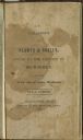
| Date: | 1836 |
|---|---|
| Description: | Title page of Increase Lapham's A catalog of Plants & Shells, Found in the vicinity of Milwaukee on the West Side of Lake Michigan, |
If you didn't find the material you searched for, our Library Reference Staff can help.
Call our reference desk at 608-264-6535 or email us at: