 Filter: Categories of Wisconsin Historical Images
Filter: County of Milwaukee
Filter: Year of 1800-1899
Filter: Subject of water
Filter: Categories of Wisconsin Historical Images
Filter: County of Milwaukee
Filter: Year of 1800-1899
Filter: Subject of water
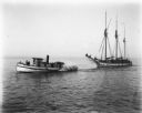
| Date: | 1898 |
|---|---|
| Description: | View across water of a tugboat pulling a sailboat towards Milwaukee on Lake Michigan. |
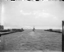
| Date: | 07 1899 |
|---|---|
| Description: | A boat leaving Milwaukee Harbor between two breakwaters, steaming into Milwaukee Bay and onward out into Lake Michigan. |
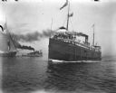
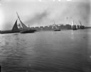
| Date: | 1898 |
|---|---|
| Description: | A large steamship, City of Racine, loaded with passengers sails towards Milwaukee Harbor. On the left a tugboat pulls a smaller sailboat out towards... |
| Date: | 1898 |
|---|---|
| Description: | Small sailboats in Milwaukee Harbor with buildings on the far shoreline in the background. There is a large sign on a roof that readsin part: "L.J. Petit..... |

| Date: | 1898 |
|---|---|
| Description: | Four sailboats in Milwaukee Harbor, one of which, The Kim, has Syl on board. In the background are railroad cars and industrial buildings. |
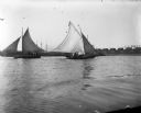
| Date: | 1898 |
|---|---|
| Description: | View across water of sailboats in Milwaukee Bay. One of the boats, The Kim, has Syl on board. In the background are industrial buildings, one of whi... |

| Date: | 1898 |
|---|---|
| Description: | Pennyfeather sitting in a small sailboat in Milwaukee Harbor. There are industrial buildings on the far shoreline, and other boats at anchor in the backgro... |

| Date: | 1894 |
|---|---|
| Description: | Sanborn Map of the Illinois Steel Co. Bay View Works in Milwaukee. |
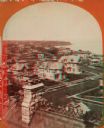
| Date: | 1876 |
|---|---|
| Description: | Stereograph of a view over rooftops of a neighborhood near Lake Michigan. Shoreline can be seen in the background. |
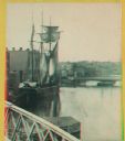
| Date: | 1880 |
|---|---|
| Description: | Stereograph. Part of a bridge is visible in the lower left corner. Under the bridge is a floating pier with advertisements painted on its sides. Another br... |
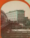
| Date: | 1869 |
|---|---|
| Description: | Stereograph of the Axtell House building, with a storefront next to it advertising "Clothing Hats Caps Sailors Outfits". A bridge is on the left and a man... |
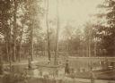
| Date: | 1888 |
|---|---|
| Description: | Several adults, two children and a dog enjoying a pond at Bracken Brae, the country home of John Johnston (1836-1904), a successful Milwaukee banker. Hilda... |

| Date: | 1878 |
|---|---|
| Description: | This map shows block numbers, wards, roads, railroads, parks, and selected buildings and includes a "Milwaukee city street guide" as well as a guide to pub... |

| Date: | 1887 |
|---|---|
| Description: | This map shows block numbers, roads, railroads, wards, and selected buildings. The map includes a "Milwaukee city street guide" and index to public buildin... |

| Date: | 1836 |
|---|---|
| Description: | This hand-colored manuscript map shows the township and section grid in southeastern Wisconsin, covering the area west to Sugar River and Four Lakes region... |

| Date: | 05 1846 |
|---|---|
| Description: | Hand-colored map of southeastern Wisconsin showing the counties of Dodge, Jefferson, Rock, Walworth, Racine (including modern-day Kenosha County), Waukesha... |

| Date: | 1830 |
|---|---|
| Description: | A hand-drawn map of the township sectioning of Milwaukee, eastern Waukesha, northern Walworth, and Racine Counties. Other items shown in the map are the la... |

| Date: | 1844 |
|---|---|
| Description: | An ink on paper, hand-drawn map of Milwaukee County that shows the sectioning of townships, the boundary of the canal grant, roads, streams, lakes, includi... |

| Date: | 1858 |
|---|---|
| Description: | An ink on paper map of Milwaukee County and the eastern portion of Waukesha County that shows the townships of Oak Creek, Franklin, Greenfield, Wauwatosa, ... |
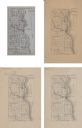
| Date: | 1875 |
|---|---|
| Description: | A series of four, ink on tracing cloth maps of Milwaukee County, Wisconsin that show the topography, the Milwaukee and Menomonee rivers, and railroad of th... |
If you didn't find the material you searched for, our Library Reference Staff can help.
Call our reference desk at 608-264-6535 or email us at: