Filter: Categories of Wisconsin Historical Images
Filter: County of Manitowoc
Filter: Year of 1900-1999
Filter: Year of 1960-1969
Filter: Categories of Wisconsin Historical Images
Filter: County of Manitowoc
Filter: Year of 1900-1999
Filter: Year of 1960-1969

| Date: | 1961 |
|---|---|
| Description: | Teacher Richard Vaughan answers a question for one of the six resident children who took the opportunity offered by the 1961 Manitowoc Summer School to lea... |

| Date: | 1961 |
|---|---|
| Description: | Mrs. Shirley Mecha, regular teacher at Meadow Brook School, helping migrant students use resources in the "library corner." |
| Date: | 1967 |
|---|---|
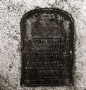
| Description: | Historical marker dedicated in 1922 on the site of a trading post. It was established in 1792 by Jacques Vieau as an agent of the Northwest Fur Company. Th... |

| Date: | 1960 |
|---|---|
| Description: | Aerial view of The Holy Family Convent and College, motherhouse of the Franciscan Sisters of Christian Charity, and liberal arts for the education of Siste... |
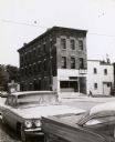
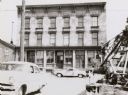
| Date: | 1964 |
|---|---|
| Description: | A mercantile building across Sixth Street from the Windiate Hotel, built in 1854. Automobiles are parked in the foreground. |
| Date: | 1964 |
|---|---|
| Description: | The annex to the Windiate Hotel was originally built adjacent to the Hotel at the east, but the annex was moved a block south. It is now a saloon and roomi... |
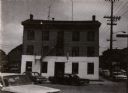
| Date: | 1964 |
|---|---|
| Description: | The Windiate Hotel located at York and Sixth Streets. The hotel was erected in 1854 and opened the same time as the mercantile store across the street. The... |

| Date: | 1962 |
|---|---|
| Description: | View across road towards loading dock of the Kingsbury Brewing Company. Printed on the side of the building are two advertisements for Kingsbury Beer. |

| Date: | 1961 |
|---|---|
| Description: | Patricia Mullins (3rd from right) and her Mariner Scout Troop pose outdoors. |

| Date: | 1964 |
|---|---|
| Description: | This map of Two Rivers shows the Rodgers street fishing area and land use. The map features a legend on the right of the types of land use. The map also sh... |
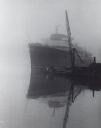
| Date: | 10 1962 |
|---|---|
| Description: | Lake steamer at dock, in fog. To the right is the boom of a crane. In front of the steamer is a tugboat. |

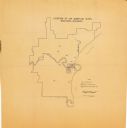
| Date: | 1960 |
|---|---|
| Description: | This map is a cadastral map and shows block and lot numbers and dimensions, additions, streets, railroad, and Kiel Municipal Cemetery. The bottom right mar... |
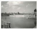
| Date: | 07 02 1960 |
|---|---|
| Description: | View across water towards the Manitowoc Shipbuilding floating drydock. Pilings and grass are in the foreground. On the far shoreline are buildings on a hil... |
| Date: | 08 1964 |
|---|---|
| Description: | This map shows the city limits, Lake Michigan, the Manitowoc River, Silver Creek, designated sample sites with manuscript annotations, central business dis... |
If you didn't find the material you searched for, our Library Reference Staff can help.
Call our reference desk at 608-264-6535 or email us at: