 Filter: Categories of Wisconsin Historical Images
Filter: County of Manitowoc
Filter: Subject of water
Filter: Community of Two Rivers
Filter: Categories of Wisconsin Historical Images
Filter: County of Manitowoc
Filter: Subject of water
Filter: Community of Two Rivers

| Date: | 1879 |
|---|---|
| Description: | Bird's-eye map of Two Rivers. |
| Date: | |
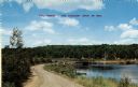
|---|---|
| Description: | View down curving road along shoreline toward a bridge. Caption reads: "Two Rivers - The Coolest Spot in Wis." |
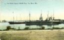
| Date: | 1900 |
|---|---|
| Description: | View from shoreline towards the coal docks on the right, with several ships in the harbor. Caption reads: "Coal Docks, Capacity 100,000 Tons, Two Rivers, W... |
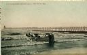
| Date: | 1908 |
|---|---|
| Description: | Group of men on a life saving crew launching a rowboat into Lake Michigan. A long pier with a lighthouse at the end bisects the horizon. Caption reads: "Li... |

| Date: | 1964 |
|---|---|
| Description: | This map of Two Rivers shows the Rodgers street fishing area and land use. The map features a legend on the right of the types of land use. The map also sh... |

| Date: | |
|---|---|
| Description: | Back of card reads: "One of the Everglade appearing sloughs running along for miles parallel with the Lake Michigan shore — This view seen from the park ... |

| Date: | 1875 |
|---|---|
| Description: | This map oriented with the north to the upper left is ink, mounted on clothe. The depths of the water are shown by soundings. A handwritten inscription on ... |

| Date: | 1810 |
|---|---|
| Description: | This map shows lot and block numbers, streets, and the public square. The bottom right margin reads: "Robert M. Eberts, Henry S. Baird, A.G. Ellis, R.S. Sa... |

| Date: | 01 08 1958 |
|---|---|
| Description: | View of Two Rivers Harbor from shoreline towards Lake Michigan. Snow is on the ground, and a fence made of thick posts and cable is along the shoreline on ... |

| Date: | 1926 |
|---|---|
| Description: | This blueprint map shows the land and its uses near Two Rivers Harbor. Lake Michigan is labeled on the left. Roads and buildings are also labeled. Original... |

| Date: | 1940 |
|---|---|
| Description: | A man is standing and looking at the door of the boathouse on the beach near the Twin River (Rawley) Point Lighthouse. The boathouse has stone sides and a ... |

| Date: | 1940 |
|---|---|
| Description: | An unidentified woman is posing sitting on the sand and looking toward Lake Michigan. The newly built shelter house, with its large windowed bay and massiv... |

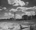
| Date: | 04 1938 |
|---|---|
| Description: | View across standing water in a swale at the foot of a large sand dune. A tall, leafless tree is reflected in the pools. The dune appears to have engulfed ... |
| Date: | 1952 |
|---|---|
| Description: | Rawley Point Lighthouse, located in the Point Beach State Forest. It is 111 feet tall. |
| Date: | 1907 |
|---|---|
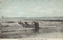
| Description: | Text on front reads: "Life Saving Crew Entering Boat, Two Rivers, Wis." A group of men launching a large rowboat into Lake Michigan. In the background is a... |

| Date: | 1957 |
|---|---|
| Description: | Text on front reads: "Two Rivers - The Coolest Spot in Wis." On reverse: "A speed boat, blue waters and a pair of water skis make a perfect day. Vacationla... |
| Date: | 1973 |
|---|---|
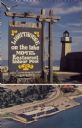
| Description: | Text on sign reads: "Lighthouse on the Lake, Motel, Restaurant, Indoor Pool." On reverse: "Lighthouse Inn on the Lake. Highway 42, 1515 Memorial Drive, Two... |
If you didn't find the material you searched for, our Library Reference Staff can help.
Call our reference desk at 608-264-6535 or email us at: