Filter: Categories of Wisconsin Historical Images
Filter: County of Manitowoc
Filter: Subject of cities and towns
Filter: Year of 1800-1899
Filter: Categories of Wisconsin Historical Images
Filter: County of Manitowoc
Filter: Subject of cities and towns
Filter: Year of 1800-1899
| Date: | 1870 |
|---|---|
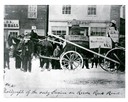
| Description: | Street parade rig, apparently to agitate against delays in construction of a railroad to connect Manitowoc to the west. In the background is a store owned ... |

| Date: | 1870 |
|---|---|
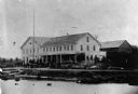
| Description: | Bird's-eye view of the city of Manitowoc with a population of 5,168 inhabitants as it appears in 1870, the year the village was granted a city charter by t... |

| Date: | 1883 |
|---|---|
| Description: | Bird's-eye map of Manitowoc. |

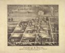
| Date: | 1868 |
|---|---|
| Description: | Bird's-eye map of Manitowoc, with four insets. Manitowoc County. |

| Date: | 1879 |
|---|---|
| Description: | Bird's-eye map of Two Rivers. |

| Date: | 05 15 1897 |
|---|---|
| Description: | Elevated view of the Chicago & Northwestern Railway yards looking northwest. The elevator of the Northern Grain Company is in the middle distance. |
| Date: | 1850 |
|---|---|
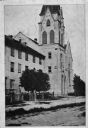
| Description: | View of the first Norwegian Church built in Gjerpen, organized October 4, 1850. Gjerpen was one of the earliest Norwegian settlements in Wisconsin |
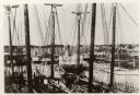
| Date: | 1887 |
|---|---|
| Description: | Some of the Old-Timers in the photograph: Steamers: Petosky (on stocks), Muskegon, Corona, A.D. Hayward, City of St. Joe, Lotus, J.F. Dayan, Grace Willia... |
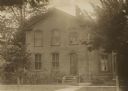
| Date: | 1890 |
|---|---|
| Description: | The home of Adolph Piening on Hancock Street (near Eight Street). The house was next door to the German Lutheran School and this site now is used by the sc... |

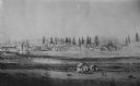
| Date: | 1856 |
|---|---|
| Description: | View of Manitowoc from the north side. |
| Date: | 1860 |
|---|---|
| Description: | Elevated view of the Roman Catholic community of St. Nazianz. |
| Date: | 1860 |
|---|---|
| Description: | Ansicht Von St Nanianz, gregundet vom Jahr 1854 bis 1860. Sr. Hochw. Hern V. Oschald. n.p., n.d. |
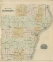
| Date: | 1878 |
|---|---|
| Description: | Outline map of Manitowoc County. Includes engraving of Wisconsin State Seal at bottom right. |
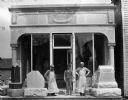
| Date: | 1898 |
|---|---|
| Description: | The storefront of Nicholas Kettenhoffen's "Graves Stones & Markers." Three men are standing in front of the store with three large grave markers. |
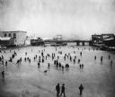
| Date: | 1888 |
|---|---|
| Description: | Elevated view of a winter scene with a large group of people skating on the frozen Manitowoc River between the 8th and 10th Street bridges. A dog trots acr... |
| Date: | 1891 |
|---|---|
| Description: | Composite photograph showing the tanneries of L.M. Sherman and Henry Vits. |
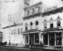
| Date: | 1891 |
|---|---|
| Description: | Exterior view of Schuette Brothers Store on S. Eighth Street. There are two horse-drawn vehicles in front of the store. There is a small mannequin in the s... |
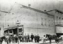
| Date: | 1888 |
|---|---|
| Description: | Men who worked for Schuette Brothers Store assembled in front of the store. There are horses on both sides of the photograph, and the one on the right is p... |
If you didn't find the material you searched for, our Library Reference Staff can help.
Call our reference desk at 608-264-6535 or email us at: