Filter: Categories of Wisconsin Historical Images
Filter: County of La Crosse
Filter: Year of 1800-1899
Filter: Year of 1890-1899
Filter: Categories of Wisconsin Historical Images
Filter: County of La Crosse
Filter: Year of 1800-1899
Filter: Year of 1890-1899
| Date: | 1890 |
|---|---|
| Description: | Brewery workers, posed in front of stacked beer barrels. Pictured (2nd row, far right) is Louis Schreiber (1861-1923) who immigrated to Wisconsin from Bava... |
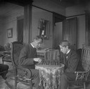
| Date: | 1898 |
|---|---|
| Description: | Reverend Henry Faville and his son, Ted, are seated around a small table playing chess in their home. |
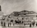
| Date: | 1891 |
|---|---|
| Description: | A painting of the new (as of 1891) bridge over the Mississippi River in La Crosse. The bridge was built by the Clinton Bridge Co. Captions read: "North sid... |
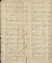
| Date: | 1890 |
|---|---|
| Description: | Pages 16 and 17 of midwife Mary Gerrard's journal in which she recorded names and birth dates of infants she delivered. |

| Date: | 1898 |
|---|---|
| Description: | Caption reads, "Sam D. Conant at cottage." A woman sits on the boardwalk and looks at the child. |
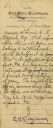
| Date: | 1891 |
|---|---|
| Description: | Letter from Fourth Assistant Postmaster General, Estes G. Rathbone, regarding the establishment of the Post Office at La Crosse and Nathan Myrick's appoint... |

| Date: | 1890 |
|---|---|
| Description: | A large group of Brewery workers posing outside of Gund's Brewery in La Crosse. In the front of the group two men are seated at a table with a large stein ... |

| Date: | 1890 |
|---|---|
| Description: | This manuscript map of Township 16 North, Range 6 West, 4th Principal Meridian, encompasses the Town of Barre and the southern portion of the Town of Hamil... |

| Date: | 1890 |
|---|---|
| Description: | This late 19th century map shows sections, state lands, Barre Center P.O. (now Barre Mills), railroads, topography, and streams and wetlands in the Town of... |

| Date: | 1891 |
|---|---|
| Description: | This map of La Crosse shows eighteen city wards in red, railroads, cemeteries, fair grounds, labeled streets, islands, and the Mississippi River. The left ... |

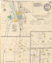
| Date: | 1893 |
|---|---|
| Description: | This map of La Crosse shows city ward boundaries in red, streets, railroads, cemeteries, Grand station crossing, the road to French Island, depots, Lake Pa... |

| Date: | 1893 |
|---|---|
| Description: | This map of La Crosse shows wards 1-20, streets, railroads, the Inter State Fair Grounds, islands, and the Mississippi River. Relief is shown by hachures. ... |

| Date: | 1890 |
|---|---|
| Description: | This map features township outlines, railroads, roads, post offices, and landownership for La Crosse County. Various communities appear in yellow, green, a... |

| Date: | 1895 |
|---|---|
| Description: | Head and shoulders portrait of Reverend John Blaschke of St. Wenceslas Church. |

| Date: | 1891 |
|---|---|
| Description: | This hand-colored map shows platted additions and subdivisions, ward boundaries, schools, churches, railroads, cemeteries, parks, businesses, factories, an... |

| Date: | 10 1891 |
|---|---|
| Description: | This blueprint map shows land ownership and buildings. Text below the title reads: "The La Crosse Heights include the ridge of land with the spurs projecti... |
| Date: | 05 1894 |
|---|---|
| Description: | Sheet 1 of an Onalaska Sanborn map, which includes an index and key. |
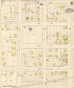
| Date: | 05 1894 |
|---|---|
| Description: | Sheet 2 of an Onalaska Sanborn map, including 2nd, 3rd, and 4th Streets. |
If you didn't find the material you searched for, our Library Reference Staff can help.
Call our reference desk at 608-264-6535 or email us at: