Filter: Categories of Wisconsin Historical Images
Filter: County of Juneau
Filter: Year of 1900-1999
Filter: Categories of Wisconsin Historical Images
Filter: County of Juneau
Filter: Year of 1900-1999

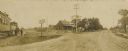
| Date: | 1905 |
|---|---|
| Description: | View down wide, unpaved street with businesses and storefronts on both sides. Captions read: "Mauston, Wis." and "State Street." |

| Date: | 1905 |
|---|---|
| Description: | Elevated view of State Street. There is a parade coming down the street, and crowds are on the sidewalks. Caption reads: "State Street, Looking East, Maust... |

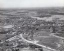
| Date: | 1905 |
|---|---|
| Description: | View across fields toward the town. Caption reads: "Birdseye[sic] view of Mauston, Wis." |
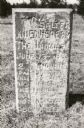
| Date: | 1940 |
|---|---|
| Description: | The Mesas and Buttes historical marker in Mill Bluff State Park. The marker reads: "Mesas and Buttes. These so-called mounds with flat tops and cliffed sid... |
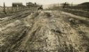
| Date: | 1926 |
|---|---|
| Description: | Car on a dirt highway west of Hustler. The highway is U.S. 12 and 16. |

| Date: | 1979 |
|---|---|
| Description: | Aerial view of Interstate I-90/94 at Camp Douglas, looking northwest. |

| Date: | 07 21 1972 |
|---|---|
| Description: | A section of the Wisconsin Interstate I-90/94 in Juneau County as most motorists know it - through the windshield. |
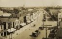
| Date: | 1920 |
|---|---|
| Description: | Elevated view of town. There is an unusual automobile parking pattern in the center of State Street. There is a sign for "Billiards" on a building in the r... |
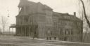
| Date: | 1919 |
|---|---|
| Description: | View across street towards the front and right side of the Juneau Hotel. |
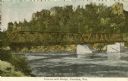
| Date: | 1905 |
|---|---|
| Description: | Petenwell Bridge. Caption reads: "Pete-eu-nell Bridge, Necedah, Wis." |
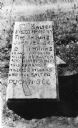
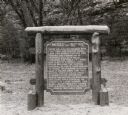
| Date: | 1925 |
|---|---|
| Description: | Salter marker between Necedah and New Lisbon, marks spot where some Indians killed a Mrs. George Salter on June 13, 1863. Mr. Salter had a log tavern here ... |
| Date: | 1940 |
|---|---|
| Description: | Salter marker between Necedah and New Lisbon, marks spot where some Indians killed a Mrs. George Salter on June 13, 1863. Mr. salter had a log tavern here ... |
| Date: | 1904 |
|---|---|
| Description: | View of crossroads where the street meets the railroad tracks. Adults and children are standing to the left next to a train. |

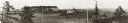
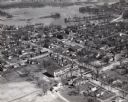
| Date: | 1957 |
|---|---|
| Description: | Aerial view of town including water tower, city streets, houses, and other buildings. |
| Date: | 1957 |
|---|---|
| Description: | Aerial view of town including houses, water tower, city streets and buildings. |
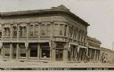
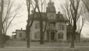
| Date: | 1910 |
|---|---|
| Description: | View of front of Farmers & Merchants Bank on a street corner. Other businesses in view include a law office and bakery. Three men are standing in front of ... |

| Date: | 1950 |
|---|---|
| Description: | Aerial view of the Highway 21 bridge and Petenwell Dam on the Wisconsin River. |
If you didn't find the material you searched for, our Library Reference Staff can help.
Call our reference desk at 608-264-6535 or email us at: