Filter: Categories of Wisconsin Historical Images
Filter: County of Juneau
Filter: Subject of land
Filter: Categories of Wisconsin Historical Images
Filter: County of Juneau
Filter: Subject of land
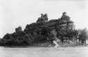
| Date: | 1937 |
|---|---|
| Description: | Castle Rock. Castle Rock is an example of a monadnock or inselberg, a geological formation common in northern and central Wisconsin. |
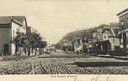
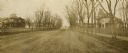
| Date: | 1905 |
|---|---|
| Description: | Unpaved road in downtown Camp Douglas. There is a bluff in the background on the right. Caption reads: "Camp Douglas, Wisconsin." |
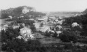
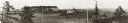
| Date: | 1910 |
|---|---|
| Description: | Elevated view of Camp Williams Town, with many houses. In the background are bluffs. |
| Date: | 1900 |
|---|---|
| Description: | View from hill of downtown Elroy, with a church steeple and buildings. |
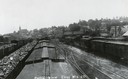
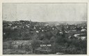
| Date: | 1907 |
|---|---|
| Description: | Elevated view above railroad cars towards downtown Elroy. Caption reads: "Partial View Elroy Wis." |
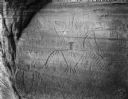
| Date: | |
|---|---|
| Description: | Thunderbird petroglyphs carved on rock face at Twin Bluffs. |
| Date: | 1858 |
|---|---|
| Description: | An ambrotype of Wonewoc, Wisconsin. Fences and buildings are in the foreground, with a tree-lined bluff behind. |

| Date: | 1858 |
|---|---|
| Description: | An ambrotype of Wonewoc. A road and fence is in the foreground, with houses beyond. A tree-lined hill is in the background. |

| Date: | 1953 |
|---|---|
| Description: | Aerial view of Wonewoc with hills or bluffs in the foreground on the right. |
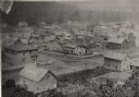
| Date: | 1886 |
|---|---|
| Description: | Elevated view of houses and buildings in Wonewoc. |

| Date: | 04 07 1988 |
|---|---|
| Description: | Panoramic view over Juneau County Highway Q, about four miles south of the entrance to Buckhorn State Park. |

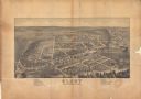
| Date: | 1905 |
|---|---|
| Description: | View across fields toward the town. Caption reads: "Birdseye[sic] view of Mauston, Wis." |
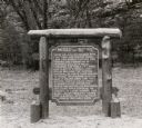
| Date: | 1940 |
|---|---|
| Description: | The Mesas and Buttes historical marker in Mill Bluff State Park. The marker reads: "Mesas and Buttes. These so-called mounds with flat tops and cliffed sid... |

| Date: | 1979 |
|---|---|
| Description: | Aerial view of Interstate I-90/94 at Camp Douglas, looking northwest. |

| Date: | 07 21 1972 |
|---|---|
| Description: | A section of the Wisconsin Interstate I-90/94 in Juneau County as most motorists know it - through the windshield. |
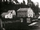
| Date: | 1895 |
|---|---|
| Description: | E.S. Minorhouse on the right, Weston-Babcock house on the left. A person is standing on the sidewalk on the left in front of the Weston-Babcock House. |
| Date: | 1905 |
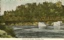
|---|---|
| Description: | Petenwell Bridge. Caption reads: "Pete-eu-nell Bridge, Necedah, Wis." |
If you didn't find the material you searched for, our Library Reference Staff can help.
Call our reference desk at 608-264-6535 or email us at: