 Filter: Categories of Wisconsin Historical Images
Filter: County of Green
Filter: Year of 1900-1999
Filter: Categories of Wisconsin Historical Images
Filter: County of Green
Filter: Year of 1900-1999

| Date: | 1925 |
|---|---|
| Description: | View from a pedestrian walkway looking towards the central business area. A concrete four-sided sign is in the center of intersection. |

| Date: | 1926 |
|---|---|
| Description: | View across street of the exterior of the Bank of New Glarus on the corner of the street. |

| Date: | 1925 |
|---|---|
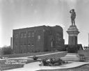
| Description: | Exterior across lawn of the three-story New Glarus high school. The school building features a decommissioned Civil War cannon near the entrance. |

| Date: | 1925 |
|---|---|
| Description: | A log cabin and park car at the Tourist Free Camp Ground. The cabin has a sign that reads, "New Glarus Settled 1845." |

| Date: | 1925 |
|---|---|
| Description: | View down the road leading to the PET evaporated milk factory. A painted sign on the factory's exterior wall claims PET evaporated milk is "milk at its bes... |
| Date: | 1925 |
|---|---|
| Description: | Outside the Swingli House, near a memorial for the first New Glarus settlers. |

| Date: | 1925 |
|---|---|
| Description: | View down railroad tracks towards the New Glarus train depot. In the background is a water tower and a windmill. |
| Date: | 1920 |
|---|---|
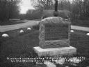
| Description: | A stone monument dedicated to the Old Lead Road. The marker reads: "The Old Lead Road. In 1828, ox-teams, guided along an ancient Winnebago Indian Trail, b... |

| Date: | 1920 |
|---|---|
| Description: | View across lawn towards Norwegian Lutheran Church and cemetery. Well-dressed men and women stand at the entrance to the building. There are graves behind ... |

| Date: | 1926 |
|---|---|
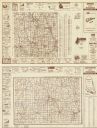
| Description: | A topographic map of Green County, showing by contours and spot heights the topographic and natural features of the county. The contour intervals are 20 fe... |

| Date: | 1906 |
|---|---|
| Description: | A map of Berlin, Wisconsin and the surrounding area, showing the old channel of the Fox River and the site of Mascouten village just south of that city in ... |

| Date: | 1969 |
|---|---|
| Description: | A map of the Elroy-Sparta State Trail and the surrounding area, showing the townships, the towns of Cashton, Sparta, in the west, and Union Center and Elro... |

| Date: | 02 13 1958 |
|---|---|
| Description: | Group portrait of eight members of the Monroe Rifle Club. They took second place at the Southern Wisconsin Rifle League contest. They are holding their rif... |
| Date: | 1984 |
|---|---|
| Description: | On verso: Map of Lafayette County, Wisconsin. Panel title. Shows roads, railroads, and highways. Includes indexes. Also includes advertisements and illustr... |

| Date: | 1911 |
|---|---|
| Description: | Shows roads, railroads, post offices, schools, houses, churches, and routes. Includes distant chart and explanation. "Price 35 cents"--Upper left margin. "... |
| Date: | 11 1946 |
|---|---|
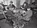
| Description: | Four men playing cards at a table with a fifth man seated on a radiator observing at left. In the foreground, a dog clears an empty beer bottle from the ta... |

| Date: | 1940 |
|---|---|
| Description: | Map features advertisements for local businesses on the left and bottom. Map includes a "LEGEND" and "DIRECTORY OF CHURCHES". Streets are labeled as are so... |
| Date: | 1935 |
|---|---|
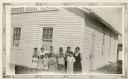
| Description: | Students pose in front of Farmer's Grove School, District No #3, Towns of York and New Glarus. |
| Date: | 1935 |
|---|---|
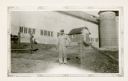
| Description: | Henry Otto Elmer, wearing a cap and bib overalls, poses in front of his large dairy barn. There are twin silos on the right with a decorative pattern in th... |
| Date: | 1935 |
|---|---|
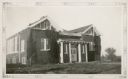
| Description: | A prominent sign identifies the Postville School, District No. 1. The school is brick, with twin gables in the front; vines grow up the walls. The gables h... |
If you didn't find the material you searched for, our Library Reference Staff can help.
Call our reference desk at 608-264-6535 or email us at: