 Filter: Categories of Wisconsin Historical Images
Filter: County of Fond du Lac
Filter: Creator Name of Unknown
Filter: Type of Map or Atlas
Filter: Categories of Wisconsin Historical Images
Filter: County of Fond du Lac
Filter: Creator Name of Unknown
Filter: Type of Map or Atlas
| Date: | |
|---|---|
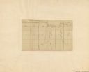
| Description: | Map shows rivers and acreages in part of Fond du Lac township and Fond du Lac, Wisconsin. |

| Date: | 1840 |
|---|---|
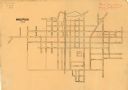
| Description: | Shows plat of town, local streets, Fond du Lac River, and part of Lake Winnebago. |

| Date: | 1956 |
|---|---|
| Description: | Includes street index. Shows local streets, parks, highways, railroads, Fond du Lac River, and part of lake Winnebago. Also includes text on points of inte... |

| Date: | 1800 |
|---|---|
| Description: | Ink and watercolor on tracing paper. Shows plat of town, local streets, Fond du Lac River, and part of Lake Winnebago. |

| Date: | 1930 |
|---|---|
| Description: | Map of Ripon, Wisconsin. In the lower left hand corner is a list of points of interest that correspond with numbers on the map. Streets and Mill Pond are l... |
| Date: | 1898 |
|---|---|
| Description: | This is a map of Waupun in 1898 that shows labeled streets, railroads, and the location of the state prison. There are annotations on the map in what appea... |

| Date: | 03 25 1931 |
|---|---|
| Description: | This blueline print map shows lot and block numbers, additions, churches, and public land in North and South wards as they were in 1884. Towards the top of... |
If you didn't find the material you searched for, our Library Reference Staff can help.
Call our reference desk at 608-264-6535 or email us at: