 Filter: Categories of Wisconsin Historical Images
Filter: County of Douglas
Filter: Subject of water
Filter: Categories of Wisconsin Historical Images
Filter: County of Douglas
Filter: Subject of water

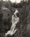
| Date: | 1890 |
|---|---|
| Description: | Big Manitou Falls on the Black River. This waterfall reportedly was called "Gitchee Monido" by the Ojibwa, which means "Falls of the Great Spirit." |
| Date: | 1940 |
|---|---|
| Description: | Big Manitou Falls on the Black River. It is referred to as the "lower falls" in the park. This 165-foot waterfall is recognized as the highest in the state... |
| Date: | |
|---|---|
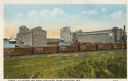
| Description: | Cargill Elevators and Great Northern Yards. Caption reads: "Cargill Elevators and Great Northern Yards, Superior, Wis." |
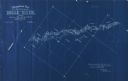
| Date: | 1898 |
|---|---|
| Description: | Topographical map of the Brule River, with white print on blue paper. There is a portion of text on the map that reads "I hereby certify that the above map... |
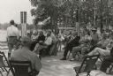
| Date: | 07 06 1937 |
|---|---|
| Description: | Dedication ceremony for the dam on the St. Croix River that is now part of the Gordon Dam County Park. Construction on this dam was begun as a WPA project... |
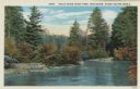
| Date: | 1913 |
|---|---|
| Description: | Colorized postcard view of the Brule River flowing through the forest. Some trees show autumn color. Caption reads: "Brule River State Park, Wisconsin. Sce... |
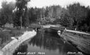
| Date: | 1935 |
|---|---|
| Description: | Elevated view of the Brule River in northern Wisconsin, flowing between a road and landscaped stone wall under a bridge and pedestrian walkway. |
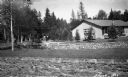
| Date: | 1935 |
|---|---|
| Description: | A one-story building is situated amongst young evergreens and surrounded by stone walls containing river raceways for spawning fish. A group of people are ... |
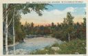
| Date: | 1913 |
|---|---|
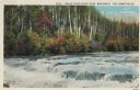
| Description: | Colorized postcard view of the Brule River flowing through the forest. Some trees show autumn color. Caption reads: "Brule River State Park, Wisconsin. On ... |
| Date: | 1913 |
|---|---|
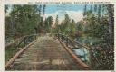
| Description: | Colorized postcard of a wooden bridge over the Brule River flowing through the forest. A person is on the far side of the bridge. Caption reads: "Brule Riv... |
| Date: | 1913 |
|---|---|
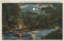
| Description: | Colorized postcard view of the Brule River flowing through the forest by moonlight. Some trees show autumn color. There is a campfire on the shore with thr... |
| Date: | 1913 |
|---|---|
| Description: | Colorized postcard view of the Lower Falls on the Brule River flowing through the forest. Some trees are showing autumn color. Caption reads: "Brule River ... |
| Date: | |
|---|---|
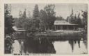
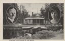
| Description: | Black and white postcard view of the President's Dining Lodge on the Brule River surrounded by trees. A bridge is on the left. Caption reads: "President's ... |
| Date: | 1926 |
|---|---|
| Description: | Black and white postcard view of Cedar Island Lodge, located on the Brule River, owned by Henry Clay Pierce, businessman and financier. It was dubbed the S... |
| Date: | |
|---|---|
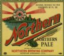
| Description: | Label for Northern Pale brewed by Northern Brewing Company. The label depicts a lake scene with evergreen trees in the background and the round Northern Be... |

| Date: | 1891 |
|---|---|
| Description: | Photograph of a painting by May Conniff Frost showing the tugboat Record of the Inman Line pulling a lake schooner through rough waters into Superio... |

| Date: | 1889 |
|---|---|
| Description: | This 1889 map of Douglas County, Wisconsin, shows the township and range grid, towns, sections, cities and villages, roads, existing and proposed railroads... |

| Date: | 1892 |
|---|---|
| Description: | This 1892 map of Douglas County, Wisconsin, shows the township and range grid, towns, sections, cities and villages, roads, railroads, trails, lakes and st... |

| Date: | 1911 |
|---|---|
| Description: | This map, taken from the 1911 Map of Wisconsin showing geology and roads by Hotchkiss and Thwaites, shows the northwest portion of Douglas County, Wisconsi... |

| Date: | 1914 |
|---|---|
| Description: | This 1914 map of Douglas County, Wisconsin, shows the township and range grid, towns, sections, cities and villages, roads, railroads, Indian trails, schoo... |
If you didn't find the material you searched for, our Library Reference Staff can help.
Call our reference desk at 608-264-6535 or email us at: