 Filter: Categories of Wisconsin Historical Images
Filter: County of Douglas
Filter: Subject of water
Filter: Creator Name of Unknown
Filter: Categories of Wisconsin Historical Images
Filter: County of Douglas
Filter: Subject of water
Filter: Creator Name of Unknown
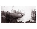
| Date: | 04 1893 |
|---|---|
| Description: | Launching Captain Abe McDougall's whaleback boat, "Christopher Columbus", from the American Steel Barge Company dock. |
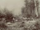
| Date: | |
|---|---|
| Description: | View from shoreline towards eight men trout fishing on the Brule River. |
| Date: | |
|---|---|
| Description: | Colorized image of the frame of a large boat being built at the shipyards in Superior. |

| Date: | 1890 |
|---|---|
| Description: | Bird's-eye map of West Superior and Superior, with insets of Wright Farm and First Building in Superior. |

| Date: | 1930 |
|---|---|
| Description: | View of bridge and Brule River monument. Placed where the Brule River is crossed by the Memorial Highway from Superior to Brule and Ashland (Highway 2). |
| Date: | 1930 |
|---|---|
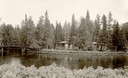
| Description: | Cedar Island on Brule River, a nationally known speckle trout stream. The island has native towering white pine and bubbling clear springs. These are some ... |

| Date: | 1913 |
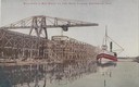
|---|---|
| Description: | Aerial bridge and harbor, with a large boat passing underneath. A lamppost and a beacon are along the walkway towards the bridge on the left. Caption reads... |

| Date: | 1900 |
|---|---|
| Description: | Elevated view of Tower Avenue. Caption reads: "Tower Avenue, Superior, Wis." |

| Date: | 1920 |
|---|---|
| Description: | Elevated view of the harbor. Caption reads: "The Harbor, Superior, Wis." |

| Date: | 1885 |
|---|---|
| Description: | Illustrated view of Superior, as well as Omaha, Kansas City, St. Paul, and Winnipeg. Caption reads: "Superior - The Last Possible Great Marine City in the ... |

| Date: | 1930 |
|---|---|
| Description: | Caption reads: "'The Old Standby' First Lighthouse Built at the Head of Lake Superior—Superior Entry — 1854 Keepers, Com. Saxton and Samuel Palmer." |

| Date: | 1915 |
|---|---|
| Description: | Elevated view of the harbor. Caption reads: "The Harbor, Superior, Wis." |

| Date: | 1910 |
|---|---|
| Description: | Caption reads: "The Great Northern. One of the largest Elevators in the World, Superior, Wis." |
| Date: | 1940 |
|---|---|
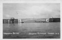
| Description: | View of the Arrowhead Bridge at the Duluth-Superior Harbor. |

| Date: | 1985 |
|---|---|
| Description: | Aerial view of the Duluth-Superior Bridge, officially named in honor of Richard I. Bong, World War II's Ace of Aces, who hailed from nearby Poplar, Wiscons... |

| Date: | 1890 |
|---|---|
| Description: | Big Manitou Falls on the Black River. This waterfall reportedly was called "Gitchee Monido" by the Ojibwa, which means "Falls of the Great Spirit." |
| Date: | 1940 |
|---|---|
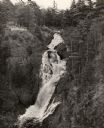
| Description: | Big Manitou Falls on the Black River. It is referred to as the "lower falls" in the park. This 165-foot waterfall is recognized as the highest in the state... |
| Date: | 07 06 1937 |
|---|---|
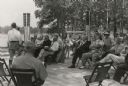
| Description: | Dedication ceremony for the dam on the St. Croix River that is now part of the Gordon Dam County Park. Construction on this dam was begun as a WPA project... |

| Date: | 1911 |
|---|---|
| Description: | This map, taken from the 1911 Map of Wisconsin showing geology and roads by Hotchkiss and Thwaites, shows the northwest portion of Douglas County, Wisconsi... |

| Date: | 1890 |
|---|---|
| Description: | This map of Douglas County, Wisconsin, published around the beginning of the 20th century shows the copper bearing formations in the county on a map that a... |
If you didn't find the material you searched for, our Library Reference Staff can help.
Call our reference desk at 608-264-6535 or email us at: