 Filter: Categories of Wisconsin Historical Images
Filter: County of Douglas
Filter: Subject of human settlements
Filter: Year of 1900-1999
Filter: Subject of water
Filter: Categories of Wisconsin Historical Images
Filter: County of Douglas
Filter: Subject of human settlements
Filter: Year of 1900-1999
Filter: Subject of water
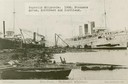
| Date: | 1900 |
|---|---|
| Description: | The Superior Shipyards showing steamers "Moran", "Northwest" and "Northland. Caption reads: "Ship Yards — McDougall Whaleback. West Superior, Wis." |

| Date: | 1913 |
|---|---|
| Description: | Bird's-eye map of Superior. "The New Steel Center." |

| Date: | 1915 |
|---|---|
| Description: | Bird's-eye view of Superior, Wisconsin, and Duluth, Minnesota on opposite shore of Lake Superior. |

| Date: | 1997 |
|---|---|
| Description: | The steel and reinforced concrete grain elevator built by the Great Northern Railroad at Superior about 1900. This contemporary photograph was taken to acc... |

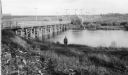
| Date: | 1930 |
|---|---|
| Description: | View of bridge and Brule River monument. Placed where the Brule River is crossed by the Memorial Highway from Superior to Brule and Ashland (Highway 2). |

| Date: | 1913 |
|---|---|
| Description: | Aerial bridge and harbor, with a large boat passing underneath. A lamppost and a beacon are along the walkway towards the bridge on the left. Caption reads... |

| Date: | 1900 |
|---|---|
| Description: | Elevated view of Tower Avenue. Caption reads: "Tower Avenue, Superior, Wis." |

| Date: | 1920 |
|---|---|
| Description: | Elevated view of the harbor. Caption reads: "The Harbor, Superior, Wis." |
| Date: | 1953 |
|---|---|
| Description: | Nemadji River at the foot of 2nd Avenue and Robertson Avenue. A man is standing near the grassy shoreline in the center. |

| Date: | 1915 |
|---|---|
| Description: | Elevated view of the harbor. Caption reads: "The Harbor, Superior, Wis." |

| Date: | 1910 |
|---|---|
| Description: | Caption reads: "The Great Northern. One of the largest Elevators in the World, Superior, Wis." |

| Date: | 1961 |
|---|---|
| Description: | Aerial view of the Duluth-Superior bridge. |
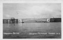
| Date: | 1940 |
|---|---|
| Description: | View of the Arrowhead Bridge at the Duluth-Superior Harbor. |

| Date: | 1960 |
|---|---|
| Description: | Aerial view with docks in the foreground. Caption reads: "Superior, Wisconsin." |
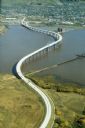
| Date: | 1985 |
|---|---|
| Description: | Aerial view of the Duluth-Superior Bridge, officially named in honor of Richard I. Bong, World War II's Ace of Aces, who hailed from nearby Poplar, Wiscons... |

| Date: | 1911 |
|---|---|
| Description: | This map, taken from the 1911 Map of Wisconsin showing geology and roads by Hotchkiss and Thwaites, shows the northwest portion of Douglas County, Wisconsi... |

| Date: | 1914 |
|---|---|
| Description: | This 1914 map of Douglas County, Wisconsin, shows the township and range grid, towns, sections, cities and villages, roads, railroads, Indian trails, schoo... |

| Date: | 1953 |
|---|---|
| Description: | This is a detailed map of Douglas County, Wisconsin, showing townships and township borders, numbered wards, roadways, and bodies of water. There are annot... |

| Date: | 1930 |
|---|---|
| Description: | Shows county system of roads which are surfaced, well graded, common, or unimproved, town roads, state trunk highways, town and village boundaries, schools... |

| Date: | 1929 |
|---|---|
| Description: | "Compliments of the Douglas County Highway Department"--Top margin. Shows state-trunk highways, county highways, town roads, trails, boundaries, and concr... |
If you didn't find the material you searched for, our Library Reference Staff can help.
Call our reference desk at 608-264-6535 or email us at: