 Filter: Categories of Wisconsin Historical Images
Filter: County of Douglas
Filter: Subject of human settlements
Filter: Subject of bridges
Filter: Categories of Wisconsin Historical Images
Filter: County of Douglas
Filter: Subject of human settlements
Filter: Subject of bridges
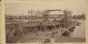
| Date: | 09 19 1892 |
|---|---|
| Description: | Captain Alexander McDougall's whaleback passenger steamer "Christopher Columbus" under construction in the shipyard of the American Steel Barge Company in ... |

| Date: | 1915 |
|---|---|
| Description: | Bird's-eye view of Superior, Wisconsin, and Duluth, Minnesota on opposite shore of Lake Superior. |

| Date: | 1930 |
|---|---|
| Description: | View of bridge and Brule River monument. Placed where the Brule River is crossed by the Memorial Highway from Superior to Brule and Ashland (Highway 2). |

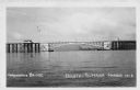
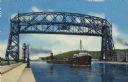
| Date: | 1913 |
|---|---|
| Description: | Aerial bridge and harbor, with a large boat passing underneath. A lamppost and a beacon are along the walkway towards the bridge on the left. Caption reads... |

| Date: | 1920 |
|---|---|
| Description: | Elevated view of the harbor. Caption reads: "The Harbor, Superior, Wis." |
| Date: | 1953 |
|---|---|
| Description: | Nemadji River at the foot of 2nd Avenue and Robertson Avenue. A man is standing near the grassy shoreline in the center. |

| Date: | 1915 |
|---|---|
| Description: | Elevated view of the harbor. Caption reads: "The Harbor, Superior, Wis." |

| Date: | 1961 |
|---|---|
| Description: | Aerial view of the Duluth-Superior bridge. |
| Date: | 1940 |
|---|---|
| Description: | View of the Arrowhead Bridge at the Duluth-Superior Harbor. |

| Date: | 1985 |
|---|---|
| Description: | Aerial view of the Duluth-Superior Bridge, officially named in honor of Richard I. Bong, World War II's Ace of Aces, who hailed from nearby Poplar, Wiscons... |

| Date: | 1800 |
|---|---|
| Description: | This pen and ink drawing with watercolor shows the course of the Black River from Rock Creek, near Greenwood in Clark County, Wisconsin, to its confluence ... |

| Date: | 1917 |
|---|---|
| Description: | This map shows streets, land owners, local businesses, the St. Louis River, and bridges. The maps reads: "Incorporated 1917." The back of the map includes ... |

| Date: | 1990 |
|---|---|
| Description: | This map shows the Minnesota Point, Wisconsin Point, Hog Island, Baker's Island, Connors Point, Blatnik Bridge, Superior Bay, Allouez Bay, the Nemadji Rive... |

| Date: | 03 23 1915 |
|---|---|
| Description: | Text on front reads: "Steamship William E. Corey, entering Duluth and Superior Harbor, Wis." A steamship entering the harbor under the Aerial Lift Bridge, ... |
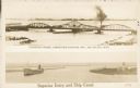
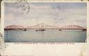
| Date: | 1907 |
|---|---|
| Description: | Postcard with two images. The top text reads: "Interstate Bridge, connecting Superior, Wis. and Duluth, Minn." The bottom text reads: "Superior Entry and S... |
| Date: | 1942 |
|---|---|
| Description: | Text on front reads: "Arrowhead Bridge, Duluth-Superior Harbor. The bridge connected Superior, Wisconsin, with Duluth, Minnesota, over the St. Louis River.... |
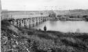
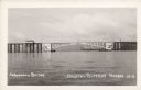
| Date: | 09 05 1906 |
|---|---|
| Description: | Text on front reads: "Duluth and Superior Bridge, in Length of Draw, Second in the World." Also called the Interstate Bridge, it was opened in July 1897. A... |

| Date: | 08 16 1946 |
|---|---|
| Description: | Text on front reads: "Greetings from Superior, Wis." Large Letter style postcard with a scene in the background of a fisherman on a Northern Wisconsin lake... |
| Date: | 07 30 1952 |
|---|---|
| Description: | Text on reverse reads: "G-1–Ore Boat Leaving Duluth-Superior Harbor, Lift Bridge Raised. Giant lake freighters leave Duluth-Superior Harbor, the world's la... |
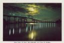
| Date: | 1937 |
|---|---|
| Description: | Cover title of souvenir folder reads: "Souvenir folder of Superior, Wisconsin 17 Natural Color Views. Caption for this image reads: "Nite View of New $21,0... |
If you didn't find the material you searched for, our Library Reference Staff can help.
Call our reference desk at 608-264-6535 or email us at: